Sunday,
10/07/2018, Pocaterra Ridge Peak 2 – Little Highwood Pass, Hwy40, PLPP,
Kananaskis, AB
· Round Trip 8.8km;
Elevation: 2593m; Elevation Gain: 660m; Time: RT - 5:45hrs (12:15 - 18:00), ascent
- 3:25hrs, descent – 2:00hrs; moderate snowshoeing with creek crossing on log
bridge at the beginning and a short section of narrow ridge walk, minimal avalanche
risk
· Books: ‘Gillean
Daffern’s Kananaskis Country Trail Guide—Volume 1’ by Gillean Daffern
References:
References:
· Pocaterra Ridge, 2667 m (8,750ft),
50.5992N -115.018W, Located between the Elk Range and Pocaterra Creek;
northwest of Highwood Pass, Province: Alberta, Park: Kananaskis, Headwater:
Bow, Visible from Highway: 40.(from peakfinder.com)
Drive
From Calgary, drive west on Hwy 1 for about 60
km, then take exit 118 heading south on Hwy 40 for about 60.6 km to Little
Highwood Pass parking lot on the left side of the road.
Driving time would
be around 1:25 hours.
Hike
We were tired and slept in resulted from the long
hike to Junction Lookout the day before, yet we didn’t want to waste this
uncommon sunny weather, so we needed a casual hike just like Pocaterra Ridge. Since
we had done the true summit (AKA Peak 4) in 2015 and didn’t need to claim the
summit anymore, we can stop anywhere we like and need this time just to relax
in the sun and enjoy the mountains.
Last time we started from Highwood Pass
day-use area and stopped at Peak 4, but in contrast we started from Little
Highwood Pass and backtracked from Peak 2 this time.
From the trailhead on the opposite of the
parking lot, we followed the well-used trail winding among trees to the front
of Pocaterra Creek. After looking a better way to cross the creek, we lost the
trail and bushwhacked a bit before rejoined the trail. The trail brought us
through the trees and up Peak 1 where we were treated with magnificent wintery
mountain scenery. After numerous pictures taking, we continued downhill back
into the woods where I was fascinated and interrupted by the golden larches
frequently. Beyond the larch forest, the trail led us up a high point and came
to an abrupt end. The ridge beyond became narrower and rockier and required
extra caution especially wearing a pair of bulky snowshoes instead of a pair of
crampon. While we were dealing with this short narrow section, we saw two
figures emerged from the skyline and quickly descended towards us. Obviously
they started from the other (south) side and were going to traverse the whole
ridge to the north end. We talked a little bit while they went by, then kept
going forward and soon reach the top of Peak 2.
From Peak 2, we could see the footprints left
by the two gentlemen we met before leading all the way to Peak 4. If only we
had another car parking on Highwood Pass parking lot or the time allowed, we would
keep going further to finish the whole ridge.
We returned the same way after 20 minutes stay
on peak 2. We didn’t regret anything but really enjoyed the encounter with the
golden rabbit that seemed to be interested in us a lot and our descent through
the larch trees. We took a lot of photos and took our time to play with our
long shadow casting on the trees. Overall, we love this simple hike with great
views, and highly recommend it doing it in fall or early winter before the
winter gate closes.
My track

Crossing hwy 40 to the trailhead
A bit overgrown trail entrance
The well-used trail winding among trees
Looking at Gap Mtn to the north after breaking out of trees
View west towards Lower Kananaskis Lake and mountains along spray valley
Elpoca Mtn

The trail brought us above treeline

Looking back with Mt Gap at right

Wonderful ridge walk to Peak 1

View east-northeast from Peak 1 with north outlier of Mt Rae rising above Elbow Lake

Mt Rae to the east-southeast from Peak 1

A valley, to the northwest, embraced by (l-r) Mt Kent, Kent North, Mt Inflexible, and Mt Lawson

A magnificent wintery mountain scenery to the south from Peak 1

Looking south to Mt Tyrwhitt with the famous window visible at left

Looking back north along the ridge we came with Gap Mtn in the background

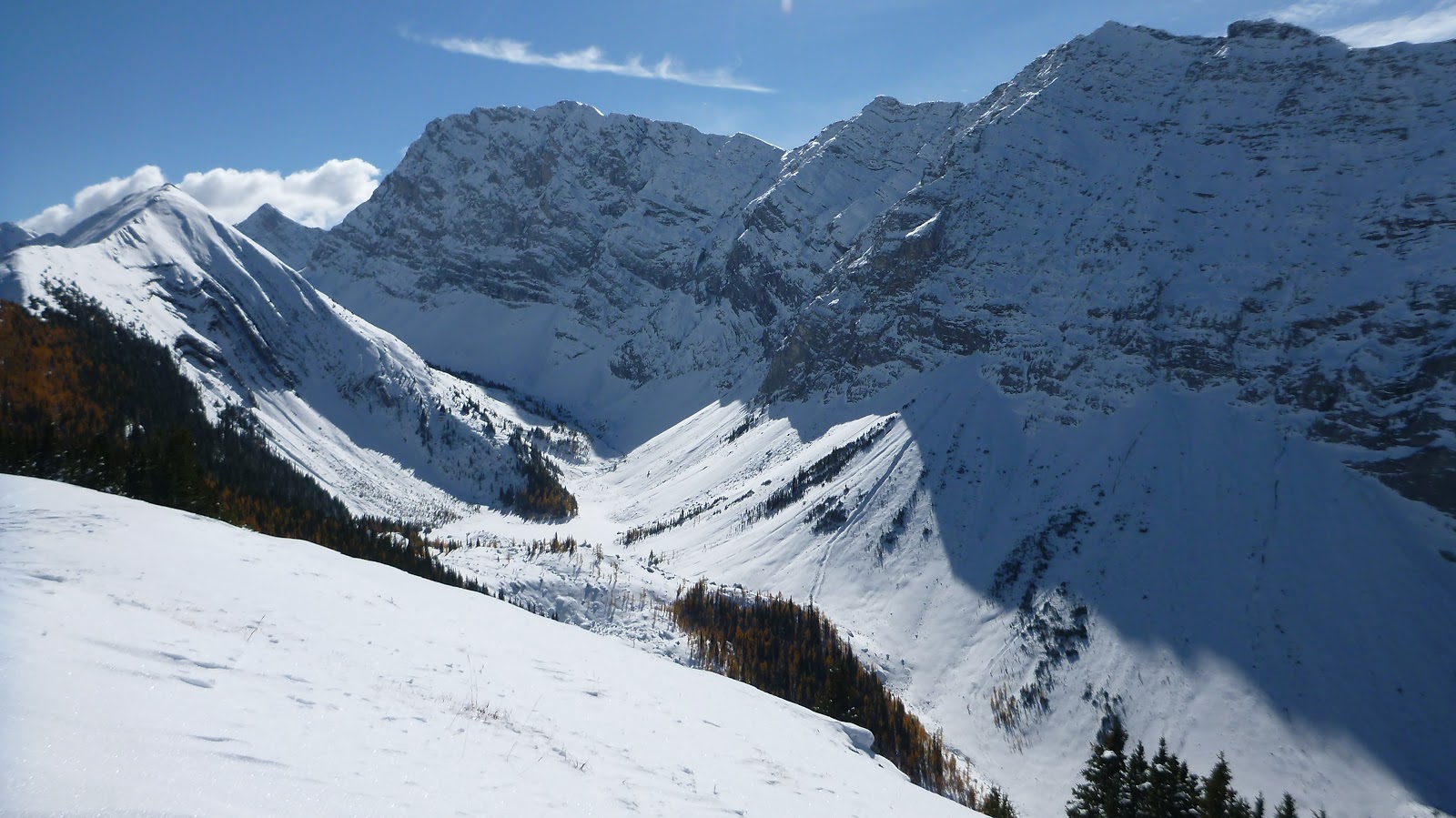
Looking south towards Mt Pocaterra(C) with Rockfall Valley below

Continuing towards Peak 2

Larches on the way

Going down into the woods

Pleasant walk through golden larches

Fascinated and interrupted by the golden larches frequently

Beyond the larch forest

Here, turn right and descend to the ridge ahead

Follow the trail up

Shallow snow in places

The trail led us up a high point and came to an abrupt end. We needed to break our own trail here and exercise extra caution when the ridge beyond became narrower and rockier

Standing on the top of our destination - Peak 2

exploring a bit further

Peak 3 (CL) and Peak 4 (C) ahead

Can see the tracks left by two gentlemen we met before leading to Peak 4, the true summit of Pocaterra Ridge

Beautiful Storm Mtn(L) and Mist Mtn(R) to the SE

Love the features of Elpoca Mtn a lot

Gap Mtn

View NW

Mt Tyrwhitt and its window again

l-r: Mt Arethusa, Storm Mtn, Mist Mtn(R) along Hwy 40

l-r: Mt Rae, Mt Arethusa, Storm Mtn

Panorama from north/left to south/right

Backtracking

Elbow Lake to the northeast with snowbound Mt Cornwall(CL) and Mt Outlaw(C) forming the backdrop

Nice ridge walk

A small downclimb

Keep going down
Narrow ridge encounter

Good jumper
This golden rabbit seemed to be interested in us a lot

Idly curious

Showing off

Looking back

Without the bulky snowshoes, the descent over the narrow and rocky part of the ridge became much easier

Taking in the views

Looking back at the other group we met on the way down

Gap Mtn

Entering the larch forest

A golden couple entwine in each other

Baby larch

Playing with our shadow casting on the trees

Back to the park lot
The end.

Crossing hwy 40 to the trailhead

A bit overgrown trail entrance

The well-used trail winding among trees

Looking at Gap Mtn to the north after breaking out of trees

View west towards Lower Kananaskis Lake and mountains along spray valley

Elpoca Mtn

The trail brought us above treeline

Looking back with Mt Gap at right

Wonderful ridge walk to Peak 1

View east-northeast from Peak 1 with north outlier of Mt Rae rising above Elbow Lake

Mt Rae to the east-southeast from Peak 1

A valley, to the northwest, embraced by (l-r) Mt Kent, Kent North, Mt Inflexible, and Mt Lawson

A magnificent wintery mountain scenery to the south from Peak 1

Looking south to Mt Tyrwhitt with the famous window visible at left

Looking back north along the ridge we came with Gap Mtn in the background

Looking south towards Mt Pocaterra(C) with Rockfall Valley below
Continuing towards Peak 2

Larches on the way

Going down into the woods

Pleasant walk through golden larches

Fascinated and interrupted by the golden larches frequently

Beyond the larch forest

Here, turn right and descend to the ridge ahead

Follow the trail up

Shallow snow in places
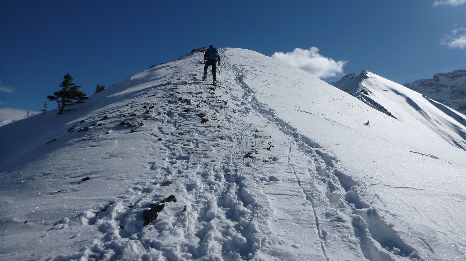
The trail led us up a high point and came to an abrupt end. We needed to break our own trail here and exercise extra caution when the ridge beyond became narrower and rockier

Standing on the top of our destination - Peak 2

exploring a bit further

Peak 3 (CL) and Peak 4 (C) ahead

Can see the tracks left by two gentlemen we met before leading to Peak 4, the true summit of Pocaterra Ridge

Beautiful Storm Mtn(L) and Mist Mtn(R) to the SE

Love the features of Elpoca Mtn a lot

Gap Mtn

View NW

Mt Tyrwhitt and its window again

l-r: Mt Arethusa, Storm Mtn, Mist Mtn(R) along Hwy 40

l-r: Mt Rae, Mt Arethusa, Storm Mtn

Panorama from north/left to south/right

Backtracking

Elbow Lake to the northeast with snowbound Mt Cornwall(CL) and Mt Outlaw(C) forming the backdrop

Nice ridge walk

A small downclimb


Keep going down

Narrow ridge encounter


Good jumper

This golden rabbit seemed to be interested in us a lot

Idly curious

Showing off

Looking back

Without the bulky snowshoes, the descent over the narrow and rocky part of the ridge became much easier

Taking in the views

Looking back at the other group we met on the way down

Gap Mtn

Entering the larch forest

A golden couple entwine in each other

Baby larch

Playing with our shadow casting on the trees


Back to the park lot

The end.
No comments:
Post a Comment