Mt Ward & Allison Peak
TRIP 285
Sunday, 7/08/2018,
Mt Ward & Allison Peak – Allison Creek Rd, Hwy 3, Coleman, Crowsnest Pass,
AB
· Round Trip 11km; Elevation:
Trailhead - 1797m, Mt ward - 2566m, Allison Peak - 2640m; Elevation Gain: Net –
843, Total – 1218m; Time: RT – 9:15hrs (10:10-19:25), Trailhead to Ward - 2:25hrs,
Ward to Allison – 2:35hrs, descent – 3:20hrs; easy scramble for Ward, difficult
scramble for Allison involving steep and exposed sidesloping and/or ledge
traversing, and/or a lots of awkward climbs and downclimbs, and/or very exposed
and difficult ridge depending on route choices
· Books: ‘Alan Kane's
Scrambles in the Canadian Rockies’ by Alan Kane
·
Allison Peak -
Located on the continental divide in the Allison Creek and Alexandra Creek
Valleys at the head of South Racehorse Creek; High Rock Range; Alberta/BC, Headwater: Oldman/Kootenay; 49.7428N
-114.646W; Visible from Highway: 3
·
Year Named:
1915; Named by: Morrison Bridgland
·
Named for:
Allison, Douglas (A fomer Royal North West Mounted Policeman, Douglas Allison
was an early settler in the Crowsnest Pass area.) (from peakfinder.com)
·
Mt Ward - Located south
of Window Mountain Lake at the head of Allison Creek Valley and at the head of
South Racehorse Creek; south of Racehorse Pass; Range: High Rock; Province:
Alberta; Headwater: Oldman; 49.7467N
-114.642W; Visible from Highway: 3
·
Named in 1917 for Ward, Captain Arthur
Clitheroe (As the secretary for the British Boundary Commission, Lieut. Ward
travelled the border from Lake of the Woods to the Continental Divide.)
(from peakfinder.com)
Drive
From Calgary, drive south on Hwy 2 / Deerfoot Trail past High River. Turn
right onto Hwy 540 or Hwy 533, and then turn left (south) onto Hwy 22. At the T
junction, turn right (west) onto Hwy 3 for about 32.2 km and turn right onto Allison
Creek Road. Follow it for about 16.6 km and turn left onto a narrower and
rougher road for about 1.3 km to the small parking of Window Mountain Lake.
Driving time would be around 3:00 hours.
Hike
While Mt Ward was just a steep hike required occasionally putting my
hands on the ground, Allison Peak, however, would be considered the most
difficult peak we have even done. It involved steep and exposed sidesloping,
small ledge traversing, lots of awkward climbs and downclimbs, and very exposed
and difficult ridge crawling (avoidable) due to our not-so-smart route choices.
The definite Window Mountain Lake Trail is
about 2 km one way and took us 40 minutes to walk through the forest. Once at
the lake, we followed a trail on the right side of the lake heading northwest,
but soon were drawn away from the lakeshore by a well-used trail up a slope to
the north of the lake. We thought it probably had a game trail traversing this
slope towards the lake’s far end, but it kept going up. So we had to drop down
to the lakeshore and found a single trail concealed by the wide-leaf shrub. After
being tricked by some trails leading to nowhere, we eventually got out of the
trees and ascended the slope southward towards the col between Mt Ward and an
unnamed highpoint.
Firstly, we hiked up aiming the col, but after
half way up, it looked like a long way to traverse to the col, so we decided to
head up the scree slope directly above us thinking it would be much shorter.
However, it shortened considerably and became very loose and steep higher up. I
had some hard time at the moment as I had to touch the ground frequently while I
thought it was just a steep hike. So we traversed to the left side to make our
life easier by following a trail close to the ridge crest all the way to the
summit.
The summit view was gorgeous, but we didn’t
stay long because more real difficult challenges were still ahead. We scrambled
down Ward’s southwest ridge to the col we forwent on ascent and started our
journey to Allison Peak. During the traverse to Allison Peak, we stayed on the
ridge crest most of the time with occasional detours to either side of the
ridge and had different kinds of scramble. The hands-on scrambles before the
intersection of Window Mtn were moderate to difficult with some exposure but
fun. However, it became tricky thereafter since we were facing a really narrow,
broken, and unknown ridge with great deal of exposure on both sides. We got
three choices here: use a faint trail on a small ledge system through the steep
slabs on east (left) slope below the ridge; tackle the ridge directly; or negotiate
the steep scree slope to the west (right) below the ridge. The narrow ledge
system on the east/left slope looked intimidating for us, so we tried the ridge
first. However, after scrambling a short distance, I found the ridge ahead not
only being narrow and exposed but also being complicate as I couldn’t look into
the whole ridge clearly. So I backed off and tried the west/right slope
thinking it would not as steep and exposed as the east/left slope. Once I
stepped into the slope, I found I was wrong about it because I felt scared and insecure, and chickened out. Gua was ahead of me at that time and had to give
up all the hard effort on this nasty slope. Backed on the start of this crux,
we spent some time to discuss the next move. Gua was a bit tired physically and
mentally because of my indecisive and disagreeing with his ridge choice. So he
let me choose. I finally picked the small ledge system on the east/left slope
as the faint trail on it induced me to think that it would be a right choice.
After scrambling carefully down to the ledge, we held our breath and walked slowly
to the safe ground without incident. After that, the remaining ridge walk was
easy and soon we stood on the summit of Allison Peak.
The weather was so nice and warm and we took
our time to admire the views and relax our legs and mind. On return, we looked
for the window mentioned by Kane in the scramble book, but found nothing. Keep
going down, we abandoned the ledge system and tackled the ridge directly. It
was spicy and full of dangerous and awkward moves from the time we stepped on
it until the time we cleared it. With hindsight, I think we should just have
used the ledge system to save some time.
Leaving the crux behind didn’t mean we could
relax since the remainder of the ridge wasn’t easy at all. There were a lot of
difficult downclimbs, although not as exposed as the crux, along the ridge and
required extra time and attention. Upon going back to the col connects to Mt
Ward, we quickly descended the northwest/left slope back to the lake and hiked
the Window Mountain Lake Trail back to the car.
It took us more than 9 hours to complete this
trip while others used much less time than us. I think it is because I wasn’t
myself that day. I felt tired and scared easily even during the ascent to Mt
Ward. I feel lucky that we could finish our goal without a scratch.

The definite Window Mountain Lake Trail is about 2 km one way and starts with a wide logging road
The path to Window Mountain Lake goes through the forest
Window Mountain Lake
A single trail
concealed by the wide-leaf shrub on the right/north side of the lake
Trails
through a small patch of trees
Being out of the trees and ascending the
slope southward towards the col between Mt Ward and an unnamed
highpoint

Looking back down at the lake
Heading up the
scree slope directly above

Traversing to the left side to make our life easier
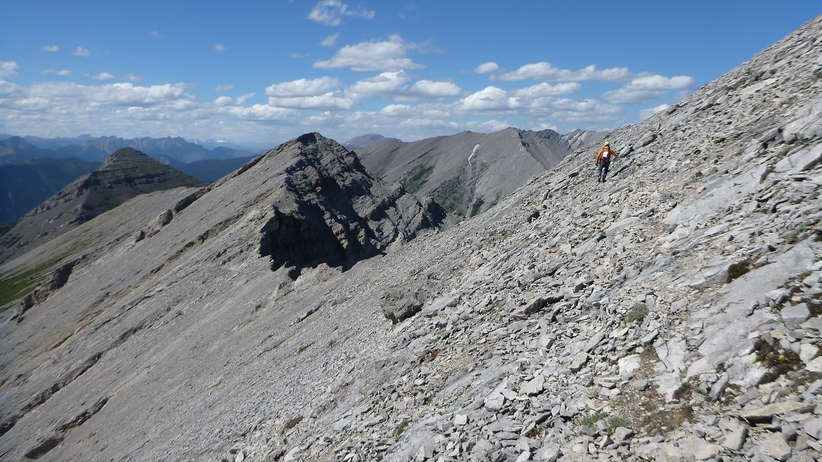
Hiking up close to the ridge crest all the way to the summit ridge
Following the ridge to the summit of Mt Ward(L) with Crowsnest Mtn in the back, window Mtn in the centre left, Allison Peak in the centre right, and the SW ridge of Mt Ward at right
Summit view west over Erickson Ridge towards Mounts Washburn, Frayn, and Terrion(?) with Mt Racehorse on right
Looking at the summit of Mt Ward(L) with Seven Sisters and Crowsnest Mountains(R) in the background

View east with Livingstone Range in the background

View south-southeast to (l-r) Seven Sisters and Crowsnest Mountains with Allison Creek Road below

Looking south-southwest to Window Mtn(CL,F) and Allison Peak(CR)

Allison Peak and the connecting ridge in between

View NW with Mt Racehorse in foreground

Racehorse Peak blocks the view to the north

View northeast toward the foothills

A closer look of Flathead Range to the south

Mt Washburn(R) to the northwest

A close-up of Mounts Frayn(L) and Terrion(R,?)

A pano (N-E-SE) from the summit of Mt Ward

A pano (SE-S-NW) from the summit of Mt Ward

Mt Ward, Window Mtn(CR), and Allison Peak(R) in one shot

A pano (S-W-NW) from the summit of Mt Ward

Scrambling down Ward’s southwest ridge towards the col we forwent on ascent

Seven Sisters(L),Crowsnest(CL), and Window(C) Mountains from the col

Starting our journey to Allison Peak

The scramble up the ridge involved awkward moves

During the traverse to Allison
Peak, we stayed on the ridge crest most of the time with occasional
detours to either side of the ridge and had different kinds of scramble
Looking back along the ridge towards Mt Ward

The easy part of the ridge

Another hard work with some exposure. The green line I took on descent would be easier but more exposed

It's much steeper than the picture shows

Fun scramble

The summit ahead on right

The south face of Mt Ward

Walking on a narrow slab hunch

Looking back

Making a detour to the right

Easy ridge walk before the intersection of Window Mtn
A trail leads to the crux of the day
Facing one of the three choices - a faint trail on a small ledge system through steep slabs on east (left) slope below the ridge

The line we took

An easy walk to the summit after the crux

Looking back down to the three choices of the crux; note the broken ridge would be tackled on descent

The summit of Allison Peak

Gorgeous views to the southeast under a blue sky
View south

View southwest
View west with Erickson Ridge in foreground
A sea of peaks across a beautiful valley to the northwest

View north

Looking north-northeast to (l-r) Racehorse peak, Mt Ward, and Window mountain

A wonderful panorama (NW-E-SE) from the top of Allison Peak

View east

A panorama (E-S-SW) from the top of Allison Peak

Tornado Mtn in the background to the northwest

A wonderful panorama (W-N-NE) from the summit

A panorama (SW-W-N) from the top of Allison Peak

Turtle(CL) and Hillcrest(C) Mountains to the southeast

Zooming in on Seven Sisters Mtn

Zooming in on Crowsnest Mtn

Seven Sisters(L) and Crowsnest(R) Mountains

Tornado Mtn to the right of centre

Mt Ward

Mt Ward and Window Mtn

Going down
Scrambling the crux ridge on descent
The ridge was spicy and full of dangerous and awkward moves from the
time we stepped on it until the time we cleared it

Watching nervously

Tricky move

Exposure on both side

Awkward move

Studying the last part of the crux

The last bit was quite loose,narrow and exposed

The easy sidesloping and ridge walk after the crux
Detouring around

Back on the ridge

A nearly vertical downclimb

Approaching the col with Mt Ward ahead

Mt Racehorse(L) and Racehorse Peak(R) to the north on the way back

Window Mtn

Back to the col. l-r: Mt Ward, Window Mtn(CR), and Allison Peak(R,B)

The northwest slope leads back to the lake
The Window Mountain Lake Trail leads back to the car
The end.
Subscribe to:
Posts (Atom)