Saturday,
11/10/2018, Odlum Ridge – Hwy40, Highwood Area, Kananaskis, AB
· Round Trip: 12km;
Elevation: 2518m; Elevation Gain: 790m; Time: RT – 7:20hrs (9:55-17:15), ascent
– 3:50hrs, descent – 2:25hrs; A difficult
hike with ultra steep slope in the trees
· Books: ‘Gillean Daffern’s
Kananaskis Country Trail Guide 4th Edition — Volume 5’ by Gillean Daffern
References:
· Odlum Ridge – 2469 m (8,190ft),
50.5017N -114.857W, Located south and west of the Highwood River and north of
Odlum Creek, Province: Alberta, Park: Kananaskis, Headwater: Bow, Major Valley:
Highwood, Visible from Highway: 40
· First Ascent – Ascent Date: 1916,
Ascent Party: Interprovincial Boundary Survey. (from peakfinder.com)
Drive
From Calgary, drive south on Hwy 2/Deerfoot
Trail, take the exit for Okotoks driving south on Hwy2A for 10.9 km, turn
right/west onto Hwy 7 towards Black Diamond. From Black Diamond, drive south on
Hwy 22 to Longview and then turn right/west onto Hwy 541 for 43.1 km to
Highwood Junction, continue driving north on Hwy 40 for about 17.1 km, turn
left and park in Lantern Creek day-use area, namely Pickle Jar Lakes Trailhead. Driving time would
be around 1:50 hours.
Hike
Odlum Ridge has three high points, the
highest of which is the easternmost which was our destination of the day. I had
wanted to do this one for years but was always deterred by the river crossing over
Highwood River. However, I recently knew from my online research that a log can
be used to cross the river, so we decided to scratch this out from our to-do
list.
It was still snowing
lightly when we set out from the parking lot and walked north along Hwy 40 for
about 500 meters to the trailhead, where had ribbon and cairn showing the start.
Having faith in the forecast of a sunny day, we hiked the trail down to
Highwood River, crossed it on a log bridge that saved our feet and time, and
then found the cutline on the other side to the left of where we crossed the
river. The cutline trail is straight forward, but we were forced to sneak into
the forest on our right by the overgrown alders in the middle of the cutline. After
hiking around 2 km from the river, a ribbon on the side of the road indicated
the right spot to leave the cutline and follow a single trail up the steep
slope on our right. This slope was the steepest section of the trip and had many
animal trails for us to follow. The grade eased greatly as we reached the
ridge crest, and the view also opened up. We then followed the ridge to the false summit
and donned our microspikes before heading to the eastern summit of Odlum Ridge.
It was really
windy and chilly atop the shelterless summit, so we walked around desperately trying
to find a windless spot, but fruitless. However, we still took a lot of pictures
while bearing the cold wind before heading back down to the false summit, which
had less wind, to take our lunch break.
On descent, we
simply returned the way we came and backed to car at twilight.

It was still snowing lightly when we set out from the parking lot and walked north along Hwy 40 for about 500 meters to the trailhead, where had ribbon and cairn showing the start.

Turn left after hiking for a minute on the trail

Crossing Highwood River on a log bridge

Crossing the river bed trending left to the other side

The entrance of the cutline on the other side

The overgrown alders in the middle of the cutline giving us headaches

Crossing a drainage before leaving the trail

The trail descends a bit after the drainage

After hiking around 2 km from the river, a ribbon on the side of the road indicating the right spot to leave the cutline

Following a single trail up the steep slope on our right

Many animal trails on this steep slope

Mt Bishop(L) under a clearing sky to the southwest

Mt Loomis at right

The sky to the southeast was a different story

The grade eased greatly as topping out on the ridge crest

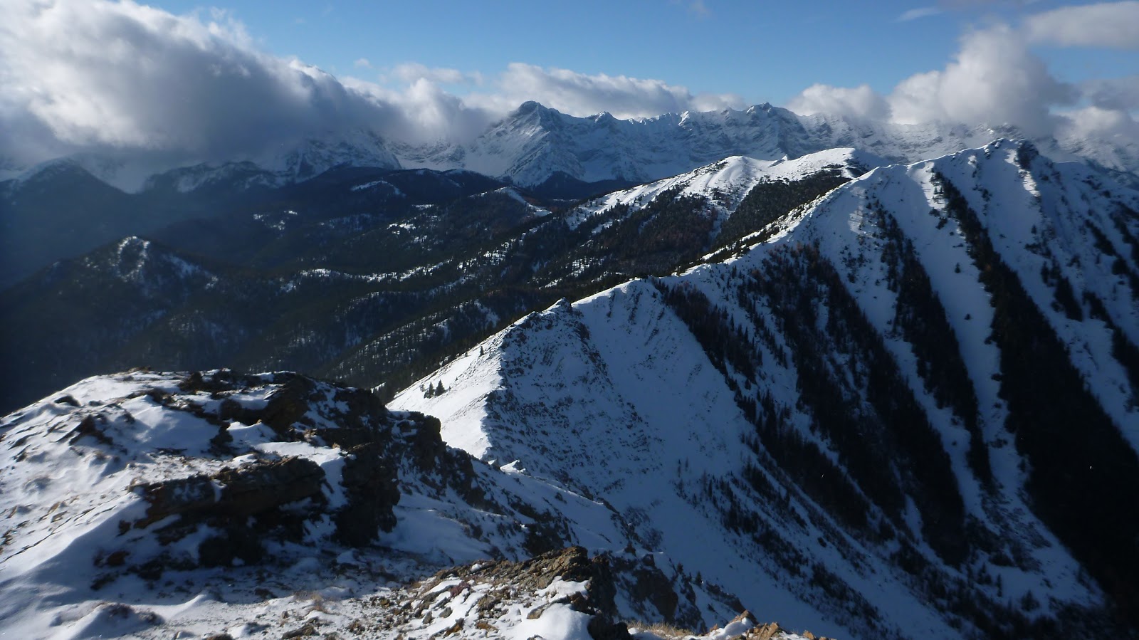
A magnificent view opening up before us: (l-r) Mt Loomis(L), Mt Odlum(C), and the ridge(R) leading to Storelk Mtn

A closer look at Mt Odlum(CL), and the ridge(R) leading to Storelk Mtn

Mt Odlum slightly to the left of centre

Mt Loomis in the centre

Following the ridge crest

Making our own way in the trees where snow buried any sign of a trail

True(L) and False(C) summits ahead

The ridge leads to the false summit(R) with the true summit(C) beyond

Looking northeast to Highwood Peak (CL) and Lineham Ridge(CR) from the false summit

The ridge between the true and false summits

Ascending a steep snow slope to the high point well before the true summit

Standing on the east summit of Odlum Ridge

Looking east across Hwy 40 to peaks in Highwood Range including (l-r) Lineham Ridge, Lineham Creek Peaks, Serendipity Peak, Mt Head, and Holy Cross Mtn

Looking southeast along the ascent ridge with Mt Burke and Plateau Mtn in the b/g

View south to Mt Bishop(CR)

View west-southwest with Mt Loomis in the centre and Mt Mt Odlum in the cloud at right

Looking west-northwest along the ridge leading to center and west peaks of Odlum Ridge with Mt Odlum(L) and Storelk Mtn(far right) forming the backdrop
Looking northwest across the highway towards Mist Mtn(CR, in clouds)

View north towards Mist Ridge(C) and the beautiful valley between her and Eagle Ridge (L,F) with Mt Burn(CL) and Gibraltar Mtn(CR) beyond

View northeast towards Highwood Peak(CL) and Lineham Ridge(R)

Highwood Peak in the centre

A close shot of Lineham Ridge

The four peaks of Lineham Creek Peaks

Mt McPhail(L) and Mt Bishop(CR) playing with clouds

The Long ridge between Odlum and Storelk beyond the Centre(R) and West(C,M) Peaks of Odlum Ridge

Mist Mtn lives up to its name

Mt Burn above Mist Ridge to the far north

Mt Burke(CL) and Plateau Mtn(CR) to the far ground

Heading down to the false summit

Not sure if they are Mt Head(L) and Holy Cross Mtn(CR)

Zooming in on Mt Burke

The clouds are still haunting Continental Divide

Backtracking after taking lunch break on the false summit

On descent


More views before going back down into the trees


Looking down the steep slope

Regain the animal trail

Back to the cutline trail


Going to the Highwood River

Mist Mtn in the last sunray

Crossing the river

Back to the trailhead

Walking the highway back to the parking lot in dusk

The moon blazes in the dusking sky

The end.
No comments:
Post a Comment