Fossil Mountain
TRIP 191
Monday, 7/25/2016, Fossil Mountain — Fish Creek TH, Whitehorn Dr, Skoki
Area, Banff NP, AB
· From Baker Lake c/g: Round Trip 8km; Elevation: 2946m; Elevation Gain: 706m; Time: 3-5hrs, ascent time: 1.5-2.5hrs; An easy
ascent from Deception Pass
· Books: “Scrambles in the
Canadian Rockies” by Alan Kane
Thanks to these helpful TR as
listed below:
·
Located south of
Skoki Mountain; east buttress of Deception Pass. Slate Range, Banff Park,
Alberta. Latitude 51; 30; 15 Longitude 116; 02; 40, Topo map 82N/09.
·
Named in 1906.
The mountain's slopes contain numerous fossils. Official name.
·
First ascended
in 1906 by Topographic SurveyJournal reference CAJ 4-112, 20-144 (from peakfinder.com).
步行路线:因为下雨我们只能放弃了路程较长、需时较多、难度较高的 Oyster Peak 而以既易且短,原本并不在计划内的 Fossil Mountain 来代替。
从 Baker Lake 营地出发时已是6pm,我们要在三个多小时的日照时间内完成全程,所以不能浪费时间。在早上进来时走过的 Baker Lake 湖边的官道上我们只顾向着西/西北方向埋首疾走,并没有停下照相,只在看见 Deception Pass 的时候抬头察看路线。眼见右 (北) 面的地形开阔平缓,我们在官道上总共走了2km 后便往右向着 Deception Pass 的方向走去。为了避免不必要的上下,在没到 Deception Pass 之前我们便对着化石山西南面的山坳走去。从山坳我们错误地跟着一条小道往右 (东北) 绕,再从左面的陡滑的碎石坡 (明显是下山路) 往北/东北方向艰难地爬上山脊,最后往右沿着山脊于7:50pm 走至不远处的山顶。
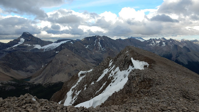
山顶平缓开阔,有一座纪念碑。当时云层越积越厚,遮住了大部份天空,光线尤其昏暗,其中一个方向的山峰更是被乌云压顶,雷声阵阵。15分钟后,眼见雷暴迫近,赶紧一路小跑着下山,回到山坳时回头却惊见山顶方向已然蓝天白云,一派晴朗。
总结:
· 上山用时1小时50分,下山用时1小时05分,在山顶停留0小时15分钟,全程用时3小时10分。
· 此山十分友好,基本不需用手,如果沿着山脊上山而不是错误地从下山路线上去,我们会花更少的时间和力气。
· 此山不矮,会是理想的观景点,性价比更是高,如果从营地出发,付出不多的时间和力气就能体会一览众山小的感觉。
在 Baker Lake 湖边的官道上看到的 Fossil Mtn

在官道上总共走了2km 后便往右向着 Deception Pass 的方向走去。而在没到 Deception Pass 之前便对着化石山(图右) 西南面的山坳走去。


来到 Fossil Mtn 脚下的山口,前方就是计划采用的山脊

背后的 Ptarmigan Lake 静躺于 Redoubt Mtn(L) 和 Ptarmigan Peak(R) 之间

被一条往右 (东北) 绕的小道迷惑而错过了原打算用于上山的山脊,转而从左面陡滑的碎石坡 (明显是下山路) 往北/东北方向艰难地往上爬

好不容易走上了连接山顶的山脊

在云影下沿着山脊走至不远处的山顶

山顶平缓开阔,有一座纪念碑(图中偏右)

东面背景为 Mt Saint Bride(L), Lychnis Mtn(C), and Bonnet Peak(cloud-covered), 与这些山已相伴三天了。

Looking south over Brachiopod and Anthozoan Mtns towards Mt Avens and Pulsatilla and Protection Mtns

View southwest

Ptarmigan Peak(C) and Wall of Jericho(CR) to the west-southwest

Looking north-northwest to the coming storm

View north-northeast towards (l-r) Cyclone and Pipestone(CL) Mtns, Mt Drummond(C), and Oyster Peak(CR,F) - our original object

Looking northeast to Oyster Peak(foreground) with Mt Douglas and Mt Saint Bride beyond

Mt Saint Bride(L) and Lychnis Mtn(CR) forms the background to the east

A closer look at Brachiopod and Anthozoan Mtns with Mt Avens and Pulsatilla and Protection Mtns beyond

The lofty Mt Temple dwarfs others around, especially Redoubt Mtn(F)

Mt Victoria to the southwest

Hungabee Mtn(L) and Mt Aberdeen(CR) to the SW

Mt ball in the centre to the far south

A zoom-out view to the west-southwest

乌云压顶,闪电雷呜,眼见雷暴迫近,赶紧一路小跑着下山

回到山坳时回头却惊见山顶方向已然蓝天白云,一派晴朗。

瞄着横在前方某处的官道穿过面前平缓的草甸。背景为 Heather Ridge(C) and Redoubt Mtn(R)

虽然夜幕将至,但天色明显好转

回到官道,Fossil Mtn 依然沐浴在夕阳下

Ptarmigan Lake 及尽头的 Whitehorn Mtn 和 Mt Victoria

最后看一眼 Fossil

图中偏右是明天的目标

回到营地

The end.
Subscribe to:
Posts (Atom)
