TRIP 181
Monday,
6/20/2016, Anderson Peak & Lost Mountain – Red Rock Pkwy, Waterton NP, AB
· Round Trip 17km;
Elevation: Anderson Peak – 2698m, Lost Mtn - 2509m; Elevation Gain: 1200m; RT Time: 7-10hrs; Easy scramble with some bushwhacking
· Books: ‘More
scrambles in the Canadian Rockies’ by Nugara, Andrew
Thanks to the TR
as listed below:
· Anderson Peak - Located between Bauerman Creek and
Blakiston Creek. Waterton Park, Alberta Major headwater Oldman River. Latitude 49;
08; 05 Longitude 114; 04; 40, Topo map 82G/01. Panorama viewpoint: Sofa
Mountain Hill. Can be seen from Red Rock Canyon Road.
· Named in 1882. Anderson, Capt.
Samuel (Capt. Anderson was the Chief Astronomer of British Boundary Commission
of 1872-1876.) Official name. Other names Millionaires Peak (from peakfinder.com).
· Lost Mountain - Located between Bauerman Creek and
Blakiston Creek; 1.5 km southwest of Anderson Peak. Waterton Park, Alberta
Major headwater Oldman River. Latitude 49; 07; 35 Longitude 114; 05; 30, Topo
map 82G/01. Panorama viewpoint: Sofa Mountain Hill. Can be seen from Red Rock
Canyon Road.
· Naming: the mountain's isolated
location is said to be the reason for its name. Official name (from peakfinder.com).
车行路线:从 Townsite Campground 出发,离开小镇 Waterton 后驶上 Hwy5 向东北方向前行约5km,然后向左拐上Red Rock Parkway 前行约14.1km 至该路的尽头,把车停在Red Rock Canyon 的停车场 (49°07'50.2"N 114°01'33.5"W or 49.130602,
-114.025987) 。
步行路线:一夜熟睡之后精神份外饱满,碧蓝的天空更令人振奋,恨不得立刻跑到山里去。然而在户外煮食和收拾东西并不麻利的我们弄到10点多才到达路径起点。
10:45am 出发,从桥上走过后马上左拐向Blakiston Falls 的方向 (西南) 走去。Blakiston Falls Trail盘绕在 Anderson Peak 东南面的山脚下,只容一人通过,虽然平坦易行,但不能掉以轻心以防摔下左下方的 Blakiston Creek。11:50am,在此小道上总共走了约4.7km 后来到了Anderson Peak 山顶的正南方,我们从这里离开官道走进右边的密林。 这个拐点没有任何标示,只能看着 GPS,尽量寻找没那么密的地方往里钻。我们钻了20多分钟才摆脱了密集的灌木来到瀑布的下面,然后从瀑布右边的山坡往上爬。跟随脚下淡淡的道印往上 (北) 走了600米路程左右,我们离开瀑布从右 (东北) 上方的一条干枯的山渠往上爬。到达顶部后再往左上方穿过一片草地,渐渐接近一道山墙。在此我们做错了决定,从这道山墙翻了上去,然后从面前越往上走越松软的碎石山坡往右上方爬上了山脊再往左沿着山脊于3:45pm 走上了 Anderson Peak 的山顶。本来如此容易的路线是不需要花5个小时上山的,可是瓜看错了图且认为这么走能更快到达山脊却不幸地碰上了走一步下滑半步的碎石坡,不但费力更费时,我当时边走边想下山岂不是很快,但却忘了还要爬 Lost Mtn,并不会从这里下山,所以后来觉得亏死了。如果要避开把我们累个半死的碎石山坡,最好是在接近山墙时继续往前 (西北) 走,跨到山渠的左边后再往北寻找合适的路线翻上山脊。
Anderson Peak 的山顶平整开阔,有足够的空间让我们支起三脚架与美景合影。虽然很累,但山上的秀丽景色和完美的天气令人重新振作,心情大好,在时间有些紧迫的情况下我们还是在山上逗留了一个小时才走向原本有些动摇了的下一个目标 ¾ Lost Mtn。
轻松地从 Anderson Peak 走到她与 Lost Mtn 之间的山坳只需10分钟左右,从山坳往西南面走近Lost Mtn 后会迎面遇到一层层的石壁,可以迎面手脚并用爬上去,也可以从左边绕过,不管是哪条路线都不会有困难。25分钟之前还站在 Anderson Peak 的颠峰上,此刻却已站在了 Lost Mtn 的山顶上面,两山相距这么近,相信没有人能抵挡一天收获两峰的诱惑吧。
Lost Mtn 上的风景由于稍矮而稍稍逊色于刚才的 Anderson Peak,而时间已不早了,所以我们呆了20分钟便下山了。重回两山之间的山坳后我们从右 (东南) 面山坡踩着碎石下山,本来下到上山时走的山渠时便要右拐随着山渠原路回去,但当时瓜认为我们上山时走的山渠还在前 (东) 面,我表示怀疑时还教育我要我相信科技 (指他手上的 GPS 路线)。虽然脚下有路印,但我觉得并不是我们走过的路,而周围的景物亦与上山时所见不同。于是我再次提出异议并强烈要求他重启 GPS 以确保无误,结果发现之前的 GPS 信号中断了,重启后显示我们往东走得太多,已过了上山时用的山渠,这时瓜才不得不承认自己被误导了。自从使用 GPS 后,我们越来越懒于研究路线了,这样省了不少时间和精神,但却减少了找路能力的培养和训练。假如出了意外,没有了依赖成性的 GPS,我们还能找到正确的路吗?
还好这次及时调整了过来,我们返身往西南方向重新走到了上来时采用的山渠,然后原路走回官道,再于8:20pm 回到 Red Rock Canyon 的停车场,然后驱车赶回露营地。
次日起来天空下着小雨,吃过早饭后我们首先去订了22日去 Ruby Ridge 路径起点的 shuttle。之所以要订车是因为这段时间整条 Akamina Parkway 都关闭了,不允许任何车辆、行人和自行车通过。如果要爬此路两旁的山峰,只能乘坐公园提供的免费巴士往返指定的那几个起点,而为了能及时赶上最后的一班车回来,只能选择耗时6、7小时以内甚至更短的路线。即使选择短程的线路,在行走的过程中也会时常顾念着末班车的事情,多少影响了步伐和心情,这也是我们此行想爬以这条公路为起点的路线而没有爬成的原因。订完 Shuttle 后天色仍然凝重,等了一段时间后决定爬难度高但很短的 Mt Galway,以便赶在天气变坏前顺利登顶。不过去到起点时才知道这一带包括我们要爬的路线因 prescribed fire 而关闭,不过后到一点的那两个年轻女孩在看完后并没有理会告示,照样走进关闭的区域,而我们并没有同犯之意,乖乖开车回去了。当时眼看天气并没有转好之意便偷闲一天,重新支起帐篷打算 nap 一下,不想又刮起了大风,把已粗略修好 的帐篷干脆吹断了,所以余下的时间我们都花在了买配件和修帐篷上。帐篷修好后已不想再用了,买了两块防水布把物品盖起,继续睡在车上。
总结:
· 登上 Anderson Peak 用时5小时0分,在此山顶停留1小时0分钟;从 Anderson Peak 到 Lost Mtn 用时25分钟,在此山顶停留20分钟;下山用时2小时50分,全程用时9小时35分。如果不是从那面松滑的山坡上山,应该会节省不少时间。
· 两山相距只有25分钟,不一起爬会很浪费。
· 从我们下山时走出来的位置离开官道开始 bushwhacking 相对会好受些。

从停车场出发,先从桥上跨过 Red Rock Creek, 背景为 Anderson Peak
然后马上左拐向Blakiston Falls 的方向 (西南) 走去
从另一座桥上跨过 Bauerman Creek

拐向盘绕在 Anderson Peak 东南面山脚下的 Blakiston Falls Trail。此路线多为只容一人通过的小道,虽然平坦易行,但不能掉以轻心以防摔下左下方的 Blakiston Creek.
Blakiston Falls
经过这里30分钟后离开官道

在官道上总共走了约4.7km 后来到了Anderson Peak 山顶的正南方,然后离开官道走进右边的密林。 这个拐点没有任何标示,只能看着 GPS,尽量寻找没那么密的地方往里钻。
在灌木中挣扎向前靠近瀑布

钻了20多分钟才摆脱了密集的灌木来到瀑布的下面,然后从瀑布右边的山坡往上爬
跟随脚下淡淡的道印往上 (北) 走了600米左右的路程
然后离开瀑布从右 (东北) 上方的一条干枯的山渠往上爬
到达顶部后再往左上方穿过一片草地
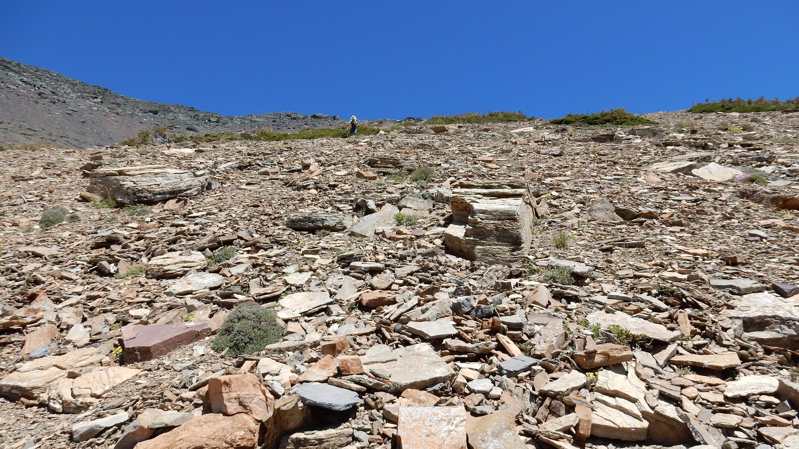
渐渐接近这道山墙。在此我们做错了决定,从这道山墙翻了上去。
然后从面前越往上走越松软的碎石山坡往右上方爬。如想避开这面走一步下滑半步,让人累个半死的碎石坡,最好是在接近山墙时继续往前(西北) 走,跨到山渠的左边后再往北寻找合适的路线翻上山脊。
快到山脊了
通往 Anderson 的山脊有些崎岖
最后一段路比较平坦易行
站在 Anderson Peak 的山顶上
站在 Anderson Peak 上欣赏东面的风景

上山时走过一段的东南山脊,后面背景里似乎隐约看见了美国境内的 Chief Mtn, 而右面邻近的 Mt Blakiston 则是 Waterton 的最高峰。

Mt Hawkins(?,C,F) to the S with (l-r) Mt Carter (C,B), Rainbow Peak(C,B),Mt Peabody(CR,B), Kinnerly Peak, and Long Knife Peak in the background nestle in GNP

Looking SW towards Lost Mtn(L,F) and Kootenai Brown Peak(R,F) with (l-r) Long Knife Peak in USA, King Edward Peak, Starvation Peak(CL,B), Miskwasini Peak, Kenow Mtn, and Langemarck Mtn in BC forming the background.

A sea of peaks to the west-northwest

View NW-N with the special looking Castle Peak in the distant centre

Looking north to (F-B) Newman Peak, Spionkop Ridge, and Loaf Mtn, with Mtn Glendowan at right

(l-r) Mt Glendowan, Cloudy Peak and Mt Dungarvan block the view to the NE

Mt Galwey to the SE

Chief Mtn(CR,B) towers beyond Sofa Mtn(CL) and Vimy Peak(CR,F)

Mt Blakiston is the highest peak in Waterton

Zooming-in towards GNP on the other side of the border

Looking Beyond Mt Hawkins to Mt Carter and Rainbow Peak with Mt Peabody at right

A closer look at peaks in GNP

Beyond (f-b) Lost, Lone, and Festubert Mountains, Long Knife(CL,B), King Edward(CR,B), and Starvation Peaks form the backdrop

A close-up of Castle Peak

A pano (L/S - R/N) from the summit of Anderson Peak

A pano (L/NW - R/SE) from the top of Anderson Peak

A pano (L/SE - R/W) from the top of Anderson Peak

Mt Glendowan(L) and Cloudy Peak(R)

Mt Dungarvan

Mounts Dungarvan(L) and Galwey(CR)

The northern tip of Anderson

Looking back at the summit of Anderson from its northern tip

Heading to Lost Mtn

Lost Mtn from the col between Anderson and Lost

Looking back up towards Anderson

The ridge leads to Lost Mtn

Circumventing an outcrop on left side easily

Standing on the top of Lost Mtn

The big cairn

Mt Blakiston to the SE from the summit of Lost Mtn

Mounts Blakiston and Hawkins

Similar views towards GNP

A hazy view to the SW

and west

and NW


View north-northeast

Summit cairn and Mt Anderson

Loaf Mtn seems to have a proper name

Panorama from the top of Lost Mtn

Heading back to the col from Lost Mtn. The red circle indicates the point we left the col and descended the slope on our right hand side
Got down here

Rejoined our ascent route here

Looking back at Lost Mtn before bushwhacking out

Better than our ascent

Looking back towards the col between Lost and Anderson

Back on the official trail

Saw two bears when driving back to the campsite


The end.

然后马上左拐向Blakiston Falls 的方向 (西南) 走去

从另一座桥上跨过 Bauerman Creek

拐向盘绕在 Anderson Peak 东南面山脚下的 Blakiston Falls Trail。此路线多为只容一人通过的小道,虽然平坦易行,但不能掉以轻心以防摔下左下方的 Blakiston Creek.

Blakiston Falls

经过这里30分钟后离开官道

在官道上总共走了约4.7km 后来到了Anderson Peak 山顶的正南方,然后离开官道走进右边的密林。 这个拐点没有任何标示,只能看着 GPS,尽量寻找没那么密的地方往里钻。

在灌木中挣扎向前靠近瀑布

钻了20多分钟才摆脱了密集的灌木来到瀑布的下面,然后从瀑布右边的山坡往上爬

跟随脚下淡淡的道印往上 (北) 走了600米左右的路程

然后离开瀑布从右 (东北) 上方的一条干枯的山渠往上爬

到达顶部后再往左上方穿过一片草地

渐渐接近这道山墙。在此我们做错了决定,从这道山墙翻了上去。

然后从面前越往上走越松软的碎石山坡往右上方爬。如想避开这面走一步下滑半步,让人累个半死的碎石坡,最好是在接近山墙时继续往前(西北) 走,跨到山渠的左边后再往北寻找合适的路线翻上山脊。
快到山脊了

通往 Anderson 的山脊有些崎岖

最后一段路比较平坦易行

站在 Anderson Peak 的山顶上

站在 Anderson Peak 上欣赏东面的风景

上山时走过一段的东南山脊,后面背景里似乎隐约看见了美国境内的 Chief Mtn, 而右面邻近的 Mt Blakiston 则是 Waterton 的最高峰。

Mt Hawkins(?,C,F) to the S with (l-r) Mt Carter (C,B), Rainbow Peak(C,B),Mt Peabody(CR,B), Kinnerly Peak, and Long Knife Peak in the background nestle in GNP

Looking SW towards Lost Mtn(L,F) and Kootenai Brown Peak(R,F) with (l-r) Long Knife Peak in USA, King Edward Peak, Starvation Peak(CL,B), Miskwasini Peak, Kenow Mtn, and Langemarck Mtn in BC forming the background.

A sea of peaks to the west-northwest

View NW-N with the special looking Castle Peak in the distant centre

Looking north to (F-B) Newman Peak, Spionkop Ridge, and Loaf Mtn, with Mtn Glendowan at right

(l-r) Mt Glendowan, Cloudy Peak and Mt Dungarvan block the view to the NE

Mt Galwey to the SE

Chief Mtn(CR,B) towers beyond Sofa Mtn(CL) and Vimy Peak(CR,F)

Mt Blakiston is the highest peak in Waterton

Zooming-in towards GNP on the other side of the border

Looking Beyond Mt Hawkins to Mt Carter and Rainbow Peak with Mt Peabody at right

A closer look at peaks in GNP

Beyond (f-b) Lost, Lone, and Festubert Mountains, Long Knife(CL,B), King Edward(CR,B), and Starvation Peaks form the backdrop

A close-up of Castle Peak

A pano (L/S - R/N) from the summit of Anderson Peak

A pano (L/NW - R/SE) from the top of Anderson Peak

A pano (L/SE - R/W) from the top of Anderson Peak

Mt Glendowan(L) and Cloudy Peak(R)

Mt Dungarvan

Mounts Dungarvan(L) and Galwey(CR)

The northern tip of Anderson

Looking back at the summit of Anderson from its northern tip

Heading to Lost Mtn

Lost Mtn from the col between Anderson and Lost

Looking back up towards Anderson
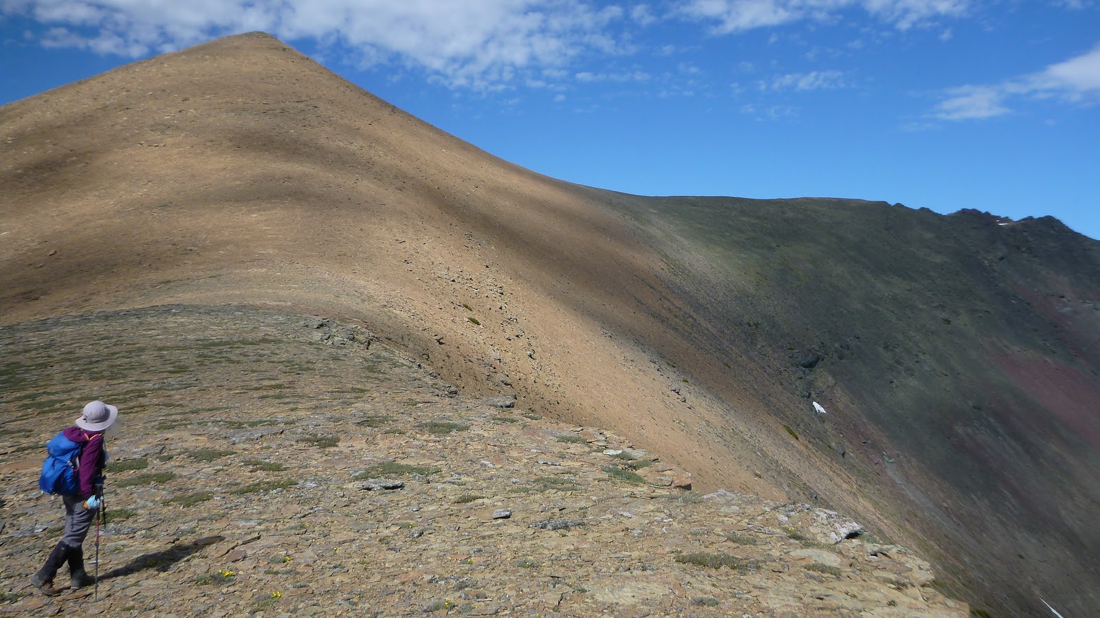
The ridge leads to Lost Mtn

Circumventing an outcrop on left side easily

Standing on the top of Lost Mtn

The big cairn

Mt Blakiston to the SE from the summit of Lost Mtn

Mounts Blakiston and Hawkins

Similar views towards GNP

A hazy view to the SW

and west

and NW


View north-northeast

Summit cairn and Mt Anderson

Loaf Mtn seems to have a proper name

Panorama from the top of Lost Mtn


Heading back to the col from Lost Mtn. The red circle indicates the point we left the col and descended the slope on our right hand side

Got down here

Rejoined our ascent route here

Looking back at Lost Mtn before bushwhacking out

Better than our ascent

Looking back towards the col between Lost and Anderson

Back on the official trail

Saw two bears when driving back to the campsite


The end.
No comments:
Post a Comment