Monday, 5/21/2018,
Cougar Peak – Benchlands Tr., B.V.W. PP, Canmore, AB
· Round Trip 18.5km;
Elevation: 2649m; Elevation Gain: 1268m; Time: RT – 10:10hrs (8:05-18:15),
ascent – 5:10hrs, descent – 4:05hrs; Moderate to difficult scramble for its
really steep and loose scree slope
References:
Drive
From Calgary, drive
west on Hwy 1 for about 85.9km and take exit 91 to a T junction, then turn
left/east onto Hwy1A/Bow Valley Trail for a short distance. Turn left again at
the next intersection onto Elk Run Blvd, and follow it for about 1.4km, just
pass the Cougar Creek. The parking lot will be on your right, namely
left/north of the creek. Driving time would be around one hour.
On foot
Cougar Peak is an unofficial name of the peak west of Mt
Fable, north of Grotto Mountain. This remote peak seems getting more traffic nowadays
according to the fact that there are several recent trail reports on the social
media. However, we were lucky to have the whole Cougar Peak for our own. As a
matter of fact, we didn’t see a single soul on the whole way up, but did met
many people who were hiking out and sport climbing in the Cougar Canyon on our
way back.
We knew it would be a long day for
us, so we started off around 8am from the Lady Mac parking lot. Walking on Cougar Creek wasn’t as easy as other hikers suggested. It involved walking
on the top of unstable rubble, crossing the creek repeatedly, detouring dead
falls and big rocks. In short, it was time consuming especially for ones do not
have long legs.
After 2:15hours (7km from parking),
we started up the steep access gully to Cougar Peak on our right leaving Cougar
Creek behind. There was a faint trail on the steep slope on the left bank of
the gully, but I preferred the treed slope for its easier grade and shade. We traversed
the treed slope on a faint trail to get to a broad scree slope and saw 3 snow
gullies further up to our left and needed to reach the middle one that leads to
the col. When we reached the middle gully, we donned our microspike before
scrambling on the left side of the snow-filled gully. Since the snow was
melting, the gully was filled with wet snow or wet rocks. We scrambled up on
the dry rock on the left side of the gully for a while until we found a
suitable spot to cross to the right side and reached the steep scree-rubble slope.
After a steep climb to the col, we turned left and hiked to the summit shortly.
It was windy up there, but we found
an amazing windless spot to rest. With time constraint, we intended to have a
short summit stay, but ended up leaving the summit after 55 minutes.
The descent from the col was really
steep, loose and scary especially when descending to the gully. Some of the
snow we stepped on on the way up had already melted, and for those had not yet, there were water running underneath. We had to be very careful to
choose our footing, thus required more time to spend with. After the narrow
part of the gully, we could finally step on a safe ground. When the slope
became easier, we took advantage of the snow to speed up a little, and then
followed our steps back to Cougar Creek and began the long trudge back to our
car.
This outing was long and suffering,
but the view was great. It did impress us in a way that we don’t think we would
repeat it in the future.
My track

Looking south towards Three Sisters from the Lady Mac parking lot

A closeup of Three Sisters
Started by walking along the Cougar Creek with Mt Lady MacDonald ahead
A small rise helps to get around the fence

Walking on Cougar Creek wasn’t as easy as other hikers suggested as it involved walking on the top of unstable rubble

Crossing the creek repeatedly

Detouring into the woods occasionally
Detouring dead falls

The access gully to Cougar Peak ahead at right with Mt Townsend in the skyline

Starting up the steep access gully to Cougar Peak and leaving Cougar Creek behind after 7km from parking

There was a faint trail on the steep slope left of the gully, but I preferred the treed slope above for its easier grade and shade

Looking down to the gully from the treed slope
Traversing the treed slope on a faint trail

Views unfolding behind

A broad scree slope heads to the base of 3 snow gullies where the middle one (red line) would lead to the col

Scrambling up towards the middle gully filled with snow

Looking down

Scrambling on the left side of the snow-filled gully after donning microspike

Looking up the gully filled with wet snow and rocks

Looking back down the steep gully

Scrambling up on the dry rock on the left side of the gully for a while then crossing to the right side

The pic below doesn't do justice to the steepness of this scree-rubble slope leading to the col

A panorama from the col with summit block to the right

Looking down to the access gully and Cougar Creek with Mt Lady MacDonald(L) and Mt Charles Stewart(R) in the background

From the col, we turned left and hiked along the ridge making one detour

Heading to the summit cairn shortly

Looking east-southeast to Mt Fable(C) with Old Fort Peak(L,B) and Goat Mtn(CL,B) sitting in the shade of the clouds and Fable
View southeast

Grotto Mtn blocks most of the views to the south

Looking southwest along Cougar Creek towards town Canmore embraced by (l-r) Big Sister(L), Ship's Prow, Mt Lawrence Grassi(CL), Miner's Peak(C), Ha Ling Peak, and EEOR(R).

To the west-northwest, Mt Rundle peeks from behind Mt Lady MacDonald to the left of centre, and the two peaks of Mt Charles Steward blocking the views to the northwest with Mt Peechee rising at far right

View north with Stenton Peak(CL) and Mt Townsend(R) in the front and Mt Aylmer looming on the left skyline

View northeast

View east

Panorama (E-S-W) from the summit of Cougar Peak

Panorama (NW-N-E) from the summit of Cougar Peak

A closeup of Mt Fable to the southeast

Mt Rundle rises above Mt Lady MacDonald to the west

Distant Fisher Peak to the southeast

Triangle-liked Wind Mountain

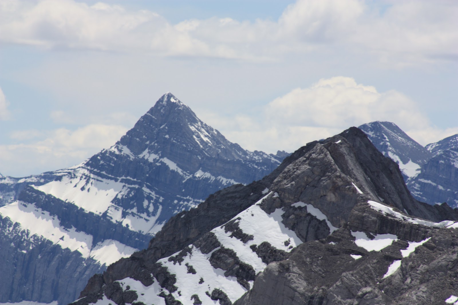
Mt Lougheed to the far south

Zooming in on Mt Nestor

Big Sister(R) dwarfs her two sisters

Aye Mtn(L) and Mt Assiniboine(R) in the background to the southwest

Looking northwest at Mt Peechee(C) with Mt Girouard(R) poking out from behind

The distant Mt Aylmer

Mt Townsend seems ready to be climbed

The Lake Louise ground can be seem in a close shot

Morrowmount(L) and Old Fort Peak(CR) to the east

Mt Fable in the background left while Cougar Peak in the foreground right

The advantaged small town Canmore

A beautiful valley to the north

Descending from the summit of Cougar Peak

Hiking back to the col

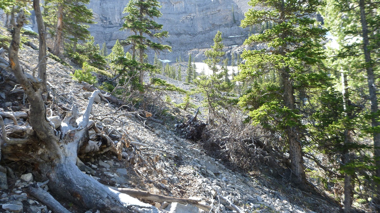
Really steep descent from the col on loose rubble

Steep and loose

The most scary part was descending to the gully

Some of the snow we stepped on on the way up had already melted, and for those had not yet, there were water running underneath.

We didn't utilize the snow gully on our descent at first because of its steepness, but did take advantage of the snow to speed up a little when the slope became easier

Last quick glimpse at Cougar peak

Then followed our steps back down

Hiking down from the access gully

Back to the Cougar Creek only to begin a long trudge

Almost back to our car

The end.

Looking south towards Three Sisters from the Lady Mac parking lot

A closeup of Three Sisters

Started by walking along the Cougar Creek with Mt Lady MacDonald ahead

A small rise helps to get around the fence

Walking on Cougar Creek wasn’t as easy as other hikers suggested as it involved walking on the top of unstable rubble

Crossing the creek repeatedly


Detouring into the woods occasionally

Detouring dead falls

The access gully to Cougar Peak ahead at right with Mt Townsend in the skyline

Starting up the steep access gully to Cougar Peak and leaving Cougar Creek behind after 7km from parking

There was a faint trail on the steep slope left of the gully, but I preferred the treed slope above for its easier grade and shade

Looking down to the gully from the treed slope

Traversing the treed slope on a faint trail
Views unfolding behind

A broad scree slope heads to the base of 3 snow gullies where the middle one (red line) would lead to the col

Scrambling up towards the middle gully filled with snow

Looking down

Scrambling on the left side of the snow-filled gully after donning microspike

Looking up the gully filled with wet snow and rocks

Looking back down the steep gully

Scrambling up on the dry rock on the left side of the gully for a while then crossing to the right side

The pic below doesn't do justice to the steepness of this scree-rubble slope leading to the col

A panorama from the col with summit block to the right

Looking down to the access gully and Cougar Creek with Mt Lady MacDonald(L) and Mt Charles Stewart(R) in the background

From the col, we turned left and hiked along the ridge making one detour

Heading to the summit cairn shortly

Looking east-southeast to Mt Fable(C) with Old Fort Peak(L,B) and Goat Mtn(CL,B) sitting in the shade of the clouds and Fable

View southeast

Grotto Mtn blocks most of the views to the south

Looking southwest along Cougar Creek towards town Canmore embraced by (l-r) Big Sister(L), Ship's Prow, Mt Lawrence Grassi(CL), Miner's Peak(C), Ha Ling Peak, and EEOR(R).

To the west-northwest, Mt Rundle peeks from behind Mt Lady MacDonald to the left of centre, and the two peaks of Mt Charles Steward blocking the views to the northwest with Mt Peechee rising at far right

View north with Stenton Peak(CL) and Mt Townsend(R) in the front and Mt Aylmer looming on the left skyline

View northeast

View east

Panorama (E-S-W) from the summit of Cougar Peak

Panorama (NW-N-E) from the summit of Cougar Peak

A closeup of Mt Fable to the southeast

Mt Rundle rises above Mt Lady MacDonald to the west

Distant Fisher Peak to the southeast

Triangle-liked Wind Mountain
Mt Lougheed to the far south

Zooming in on Mt Nestor

Big Sister(R) dwarfs her two sisters

Aye Mtn(L) and Mt Assiniboine(R) in the background to the southwest

Looking northwest at Mt Peechee(C) with Mt Girouard(R) poking out from behind

The distant Mt Aylmer

Mt Townsend seems ready to be climbed

The Lake Louise ground can be seem in a close shot

Morrowmount(L) and Old Fort Peak(CR) to the east

Mt Fable in the background left while Cougar Peak in the foreground right

The advantaged small town Canmore

A beautiful valley to the north

Descending from the summit of Cougar Peak

Hiking back to the col

Really steep descent from the col on loose rubble

Steep and loose

The most scary part was descending to the gully

Some of the snow we stepped on on the way up had already melted, and for those had not yet, there were water running underneath.

We didn't utilize the snow gully on our descent at first because of its steepness, but did take advantage of the snow to speed up a little when the slope became easier

Last quick glimpse at Cougar peak

Then followed our steps back down

Hiking down from the access gully

Back to the Cougar Creek only to begin a long trudge

Almost back to our car

The end.
No comments:
Post a Comment