Sunday, 6/05/2016, Boom Mountain — Hwy93 S, Banff/Kootenay NP border, AB/BC border
· Round Trip: 14km; Altitude: 2760m; Height Gain: 1110m; RT Time: 7-10h; E-M Scramble with terrible bushwhacking
· Books:
“Scrambles in the Canadian Rockies” by Alan Kane
Thanks to the TR
as listed below:
· Located on the continental divide
between Boom Lake and Chickadee Valley; north buttress of Vermilion Pass. On
the border of Banff & Kootenay parks, Alberta/BC border. Major headwaters
Bow and Kootenay rivers. Latitude 51; 15; 05 Longitude 116; 04; 35, Topo map
82N/08. Can be seen from Highways 1 and 93S.
· Named in 1908. Boom Lake lies below the
mountain. It was named after the driftwood, derived from avalanche debris,
which looked like a lumberman''s boom. Official name.
车行路线:从 Calgary 西北出发,沿着北段 stony trail 向西行驶,然后在 Exit 36离开向右拐上 Hwy1西行约141km 后在 Bow Valley Pkw/Castle Junction 出口离开,再向左拐上 Banff Windermere Pkwy, 即南段 Hwy93前行约10.1km 后向左拐进有三支旗帜的停车场 (51°13'41.1"N 116°03'00.3"W or 51.228079, -116.050098)。这个停车场刚好位于 AB 和BC 省交界,Continental Divide 上,车程约1小时40分。
步行路线: 9:50am 从停车场穿过马路走进对面的树林,然后从树木较疏的地方走向位于西北方向的 Chickadee Valley。本以为开始找到的一些道印能减轻 Bushwhacking 的痛苦,带领我们穿过这片树林走至Chickadee Valley 的深处,但道印似有还无,很快便消失了,我们只好尽量沿着小溪右 (北) 岸的边缘行走以避开稠密的灌木。全程4km 的密林穿行我们足足忍受了2个小时,而期间更是走得心浮气躁,连路况也忘了照下,不过,在到处一样,没有特色的森林里面,照片并没多少参考价值。
走了两小时,树木终于不那么密了,也终于看见了 Boom Mtn 以及她西南面山坡上那一道道的山渠,但我们还是要在树林里往西北方向再走20分钟才彻底离开了密林来到我们用于上山的那条山渠的下面。离开密林后我们本该可以走快些的,但炎热的天气拖慢了我们的脚步。当天艳阳高照,实在太热了,我居然穿上了短袖,而瓜更是有些许中暑,全身乏力,没精打彩且频繁地停下喝水,全然没了前一天的风采,我不由得担心所带的水是否足够。还好我状态回升,只在吃东西时才喝一口水,也一路领前,挑起了找路的重任。
离开密林后,我们先是走过了一堆大石头,然后走在草木稀疏的泥石坡上,当脚下的石块越来越多越大,山坡上有很多大石块时,我们往左横过山渠,从有树的山坡往上爬。虽然山坡很坡,但树荫能给我们纳凉,也可避开硌脚的石头坡。在快接近悬崖峭壁时,我们少有地在树下休息了一会儿,补充了能量和水后才走近岩壁。从这里既可以往左 (西北) 绕过岩壁再往右 (东北) 从比较容易的地形翻上连接山顶的山脊,也可以继续往上从一些缺口翻过岩壁接近更高一层悬崖峭壁再往左 (西北) 绕过岩壁,然后同样地往右 (东北) 从比较容易的地形翻上连接山顶的山脊。我们选择往左绕过第一层岩壁,因为岩壁下有明显的小道往左绕。绕得足够远后我们横过一道充满碎石的山渠到了它的西面,然后往右 (北) 向上爬。这面山坡除了中间一段比较平缓,其余部份有些陡,而且脚下多是松动的石块,要非常小心才不会滑倒。
2:45pm 当翻上了平缓而宽阔的山脊时我有些茫然了,诺大的山脊山顶在哪呢?原来山顶还不在视线范围,要往右上方 (东北) 走了半小时才于 3:15pm 到达了 Boom Mtn 的最高点。
山上的风景很美,雪未化尽的山峰在蓝天映照下份外出彩。按说这么壮丽的景色必会令人兴致高昂,但我们实在太累了,尤其是瓜,一到顶便坐下不愿再动,而时间也紧迫,补充了能量及留下倩影后我们于4:10pm 原路下山。下山依然要走那4km 的密林,但总体而言比上山时快很多,最后于7:35pm 回到了起点。
总结:
· 上山用时5小时25分,下山用时3小时25分,在山顶停留0小时55分,全程用时9小时45分。
· 4km 的 bushwhacking approach 令人十分郁闷狂躁几近疯掉,烈日下没完没了的爬坡更令瓜直言:如果恨谁,就让他来爬此山。
· 山上风景纵然美得令人窒息,也不会有勇气再来第二次了。
My Route

在停车场就能看见Boom Mtn,上山路线则要绕到左面才能看见。

从停车场穿过马路走进对面的树林

然后从树木较疏的地方走向位于西北方向的 Chickadee Valley

走了两小时,树木终于不那么密了,也终于看见了 Boom Mtn 以及她西南面山坡上那一道道的山渠/雪崩坡。

但我们还是要在树林里往西北方向再走20分钟才彻底离开了密林走至我们用于上山的那条山渠/雪崩坡。下图LG正前方堆满大石块的地方便是山渠/雪崩坡的初段。

走过一堆大石头后走在了草木稀疏的泥石坡上

背后的风景已然美不胜收

当脚下的石块越来越多越大,山坡上有很多巨石时,我们往左横过山渠/雪崩坡,从有树的山坡往上爬。

走近第一层岩壁后跟随明显的小道往左绕过这层岩壁

绕得足够远后我们横过一道填满碎石的山渠。回望横过的碎石山渠。


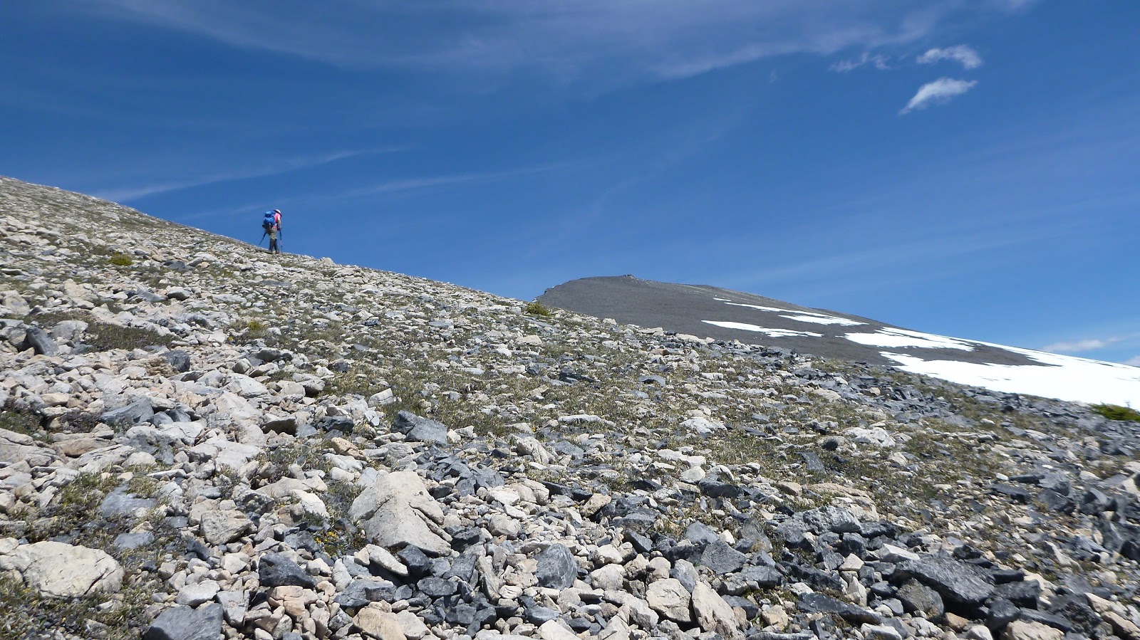
然后往右 (北) 从碎石山坡向上爬。

这面山坡的中段比较平缓

累了便看看风景。Quadra(C) & Bident(R) Mountains

但其余部份有些陡,而且脚下多是松动的石块,要非常小心才不会滑倒。

前面的路况

身后让人磨牙的碎石山坡

坡度还是挺大的

翻上山脊之前的路况,坡度有所减缓。

从右边的缺口爬上来

走在平缓而宽阔的山脊时让人有些茫然,诺大的山脊山顶究竟在哪呢?原来山顶并不在视线范围,还要往右上方 (东北) 走。
如梦似幻,美得心醉。

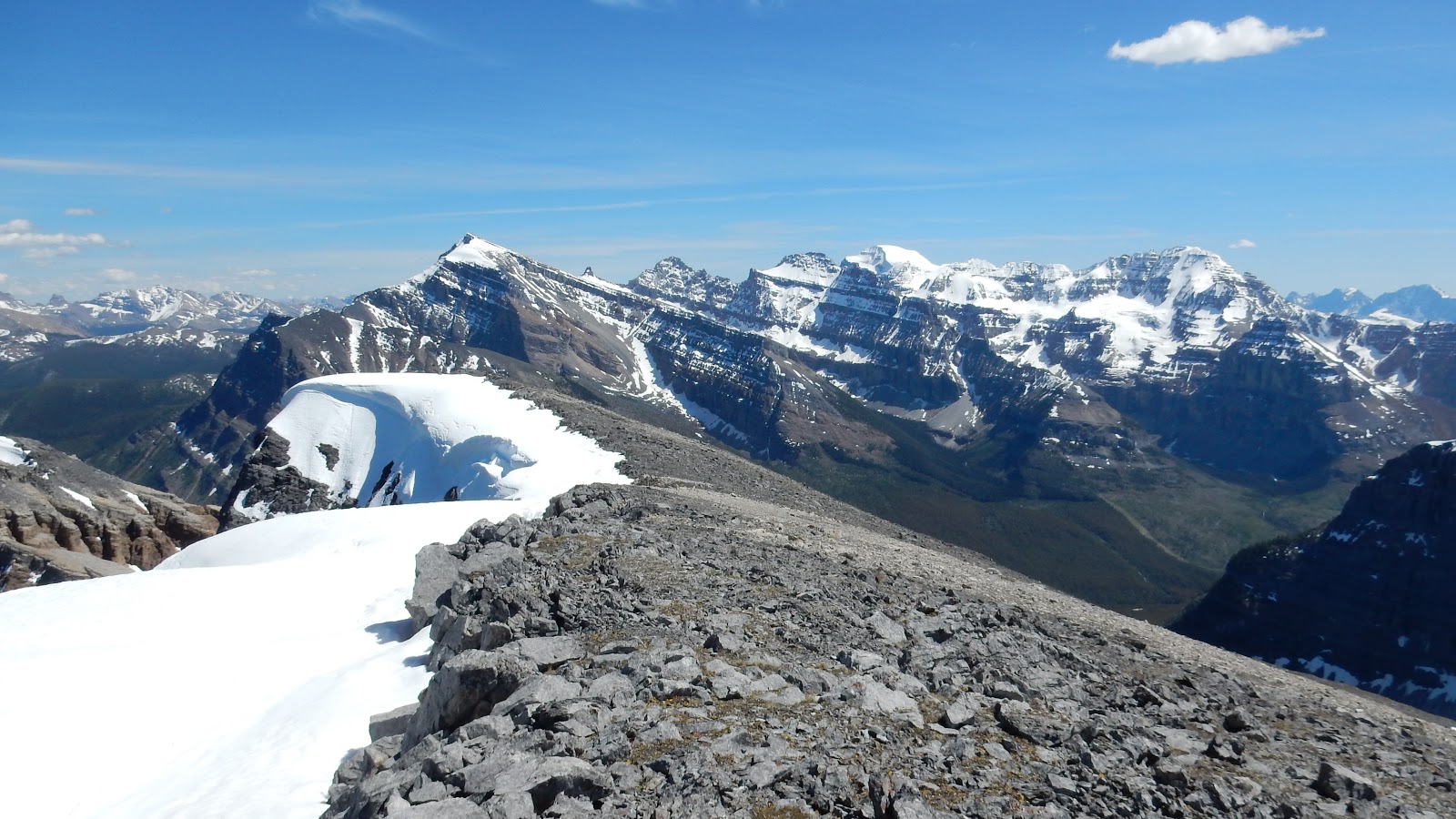
立于 Boom Lake 之上的是 Quadra & Bident Mtns(L) 以及 Panarama Ridge & Mt Bell(R),不过背景里的 Mt Temple (C,B) 其实更抢镜。

还不是山顶

快了

终于登顶了

东至南的山景:图左以 Sawback Range 为背景,从左至右包括Mt Ishbel 的右肩,Cockscomb Mtn,The Finger,Mt Cory。图中背景为Massive Range,包括Pilot Mtn, Mt Brett, Mt Bourgeau。图右近景为 Storm Mtn。

Storm Mtn(cl), Mt Ball(cr,snowy), Beatrice Peak(r of Ball) and Stanley Peak(r of Beatrice) dominates the view to the south.
Looking south-southwest into kootenay National Park

Views to the west with upper Chickadee Valley below

Looking northwest towards Mt Temple

View north with Mt bell in the foreground

The imposing rockwall of Protection (L) and Castle (R) Mtns across Hwy1 to the NE

The copper register that I wasn't able to open

View east towards Sawback Range

Mystic Peak on the left of centre

Mt Ishbel

Cascade Mtn (C,B) and Mt Peechee (CR,B) poke from behind Cockscomb Mtn (C,F) and The Finger (R,F)

The Finger (L), Mt Cory (C), Mt Rundle (R) to the SE

Pilot Mtn(L,B) and Mt Brett(CR) rise above Copper Mtn(L,F) to the SE

A close look of Old Goat Mtn(L), Eagle Mtn(CR), and Mt Howard Douglas(R of Eagle)

Storm Mtn across Hwy 93S

Mt Ball(C) and Beatrice Peak(R)

Mounts Whitetail(CL) and Verendyre(CR) in the background

looking south over the saddle between Mt Haffner(L) and Vermillion Peak(R,out of sight) to Numa Mtn with Floe Peak in the background

Foster Peak(CR,B) is the highest one rearing up above Vermillion Peak(CR,F)

The air was so clear that even the distant Mt Goodsir(B) could make her presence

Some of the Ten Peaks including Mt Allen,Deltaform Mtn (C,B), and Mt Tuzo appear behind the col between Chimney Peak(L) and Quadra Mountain

Quadra and Bident Mountains in the centre with the mighty Mt Temple in the background right

Zooming in on the handsome Mt Temple

Mt Bell directly to the north

Catching a glimpse of Pipestone River Valley and part of the Mt Hector over the lower ridge of Mt Bell

Mt Richardson(L), Pika Peak(CR), and Ptarmigan Peak(R) in the Skoki Area to the north

The giant Mt Douglas sits deeply in the Skoki

Mt St. Bride, another giant in Skoki

A Pano from east(L) to southwest(R)

A Pano from southwest(L) to north(R)

A Pano from north(L) to southeast(R)

Time to leave

Looking down to Boom Lake

碎石山坡

提前走下山沟,却未能找到松软的碎石地形

从雪崩坡下面往回看

回到起点

The end.
No comments:
Post a Comment