Saturday,
12/09/2017, Monarch Ramparts – Sunshine Village, Banff NP, AB/Kootenay NP, BC border
· Round Trip:
22km; Elevation: 2428m; Elevation Gain: Net – 666m, Accumulated – 985m;
Time: RT – 7:35hrs (9:00-16:35), ascent – 3:55hrs, descent – 2:40hrs; An easy to
moderate snowshoeing with minimal risk
· Book:
References:
· Located on the continental divide at
the head of Healy Creek and the head of East Verdant Creek; southern buttress
of Healy Pass; eastern buttress of Redearth Pass; on the border of Banff &
Kootenay parks, Alberta/BC border. Major headwaters Bow & Kootenay rivers.
· Latitude 51; 04; 40 Longitude 115; 36;
35, Topo map 82O/04.
· Naming: This long ridge begins at
"The Monarch" and trends north-northwest. Cliffs on the Alberta side
give it the look of a defensive fortification. Official name. (from peakfinder.com)
Drive
From
Calgary, drive west
on Hwy 1
for about 119km and take the exit for Sunshine Road, drive another 9km to the
base of Sunshine Village and park in the big parking lot on the left. Driving
time would be around 1:30 hours.
Hike
Knowing
the weather would be in our favour, we headed to Sunshine Village again in less
than two months. But this time we were going to Monarch Rampart via Healy Pass
Trail and had to share the parking lot with many skiers who seemed to arrive
much earlier than us even though they didn’t have a long approach as we did.
When we stepped out of
the car, we all felt very cold, but I wasn’t scared away by the chilly air in
the parking lot as I knew it would be warmer at our destination because of the
inversion – a reversal of the normal decrease of air temperature with altitude.
After gearing up, we
walked through the crowd, with our snowshoes in hands and ignoring some curious
glance, to Healy Pass trailhead and started our hike. Not long after the first bridge, we put the
snowshoes on to free our hands in spite of the fact that the trail was well
packed by other users. During the long approach in the woods, we surprisingly
surpassed five backcountry skiers, which indicated that we were at a good pace.
Marching on Healy Pass trail for two hours or 7km from the trailhead, we finally reached the broad meadows and entered a pure peaceful world. The views
and sky were as beautiful as the ones back in January 2016 when we visited
Healy Pass Peak. I think the meadows themselves really stand out and are worth
a visit if you can bear the long hike in.
Following an old ski
track, we made it to the foot of Healy Pass. From here, the slope leads to the
pass looked steeper than I thought, thus did concern me a little. However, I
still chose this route, although I knew there was a safer route to our left, because
Gua thought it wasn’t steep enough to slide, and we never visited the pass
before. Once we followed the zigzag ski track up the slope, Gua realized his
underestimate since he was soon gasping for air. Fortunately, the slope is
short and we quickly reached the pass and kept following the ski track to the
north end of Monarch Rampart. Before heading to the south along the long ridge,
we climbed up the high point at the north end because we were confused about
the highest point and didn’t want to miss it. Backing down from the northmost
high point, we continued our walk on the easy ridge southward while taking the
views around us, and finally located the so-call summit of Monarch Ramparts in the middle of this long ridge.
The summit is flat and
wide enough for us to wander around to take in the view; meanwhile tolerate the
wind from all directions. When we couldn’t stand the wind anymore, we started
to head down the way we came up except that we forwent Healy Pass, but descended
from the col to the south of the northmost high point instead.
As we rejoined the
ascent route in the meadows, we saw a group of three skiers having last fun with
their skis and leaving the meadows like us. With the slightly down hill, skiers
are usually faster than our snowshoers, but with a newbie in the group, these
three skiers were an exception. They were passed by us and never caught us up
although we were passed by other groups of skiers showing up from nowhere. The hike
back was not only tedious but also a bit worrisome because of the skiers
approaching from behind. I had to look back frequently as I was fearful of
being struck down by them. Thanks to god, eventually we hiked back
to the parking lot safely just before sunset.

右边的路通往 Healy Pass

途经雪崩坡

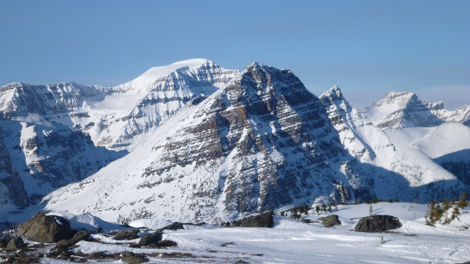
其中一处开阔地,背景是 The Monarch(左) 和我们的目标 Monarch Ramparts(平直的山脊)

另一处开阔地

月儿淡淡地注视着静谧的大地

两小时后终于步入了一望无际的雪原,置身于童话世界

背后的风景

长达3公里的Monarch Ramparts的最高点在图中间偏左,但我们先要翻上最右/北边的山脊,再往左/南走至最高点。

从图中偏右这个看上去很缓的山坡翻上 Healy Pass

在山坡上回望来路

在山坡上察看另一条更缓更安全的路线。下山时用的就是此线(绿线)
翻上山坳后继续跟着雪板印绕到眼前这个小山包的另一面
从左边较缓的雪坡翻上去
上去后将会爬上右上方的高地
爬上最北端的高地前察看一下 Monarch Ramparts 那长长的山脊
从右下方上来的
站在 Monarch Ramparts 的最北端
从Monarch Ramparts北面高地往西北面看到的风景多为 Ball Range 的山峰,包括(左前至右后): Sugarloaf Mtn(圆矮的山包), Scarab Peak, Haiduk Peak, Pharaoh Peaks(中前右), Mt Ball, Stanley Peak, Storm Mtn(far right)

北面风景, 图中央为Healy Pass Peak

东北面有十分吸睛的 Mt Bourgeau(CL) 和 Eagle Mtn(R)立于美丽的山谷之上

东南面有许多熟悉的身影

短暂停留后瞄着南面高点继续前行

有些起伏的地形

回望北面的高地

前面要穿过一小片树林。此处的雪还挺多, 但承托力还行。

回望穿过的小树林

被风吹就的波浪

快到最高点了

算是登顶了

西北面,来的方向

Mt Ball(B) and Pharaoh Peak(F)

对是否身处最高点心存疑虑,便继续往前走

东面风景。这个山脊也太宽了,占了画面的一半。

东南面。虽然在阴影里,Mt Assiniboine(R,B) 还是被轻易地认了出来。

The Monarch(R) 挡不住刺目的光线却挡了南面的风景

西南面皆为BC境内的山峰

西面这堵屏障为无名氏

西北。这些山峰多在AB、BC两省边界上

北面能看得很远,包括 Mt Hector 和 Skoki 域内的山峰。

东北面的 Healy Pass Peak(L), Pilot Mtn(no snow covered), Mt Brett(C), Mt Bourgeau(R)

Mt Bourgeau(L), Eagle Mtn(CR) 两者间的背景为 Fairholme Range 的 Mt Inglismaldie, Mt Girouard, Mt Peechee. Eagle 右面依次为 Mt Howard Douglas, Lookout Mtn, Brewster Rock.

一个多月前爬过的 Eagle Mtn似乎雪量不多

左起: Mt Howard Douglas, Lookout Mtn, Brewster Rock

Fatigue Mtn with summit at right

Zooming-in

Mt Brett

Mt Bourgeau 在前,Cascade Mtn 在后

近看(l-r)Mt Inglismaldie, Mt Girouard(CL), Mt Peechee

From behind Simpson Ridge(CR,F), Mt Assiniboine towers above other peaks

下山了

Mt Ball(C,B) and Pharaoh Peak(C,F) again to the NW

舒服

Mt Hector in the far background

A closer look at (l-r) Mt Richardson(L), Pika Peak, Ptarmigan Peak, and Redoubt Mtn located in the distant Skoki Area

被起伏的山峦谷地深深吸引

美丽安详不忍离去

再看一眼南面的 Mt Assiniboine

走到最北面的高点前的山坳时,从右面缓坡下山(绿线)

比上山时的山坡缓多了

走在山影里有点冷

从这里挑选相对平缓的线路下去再往右走

再往前走便重踏来时路, 而左边是一个冰封雪盖了的小湖

重踏来时足印穿行于雪原间

即将走进树林时遇到三个滑野雪者, 他们滑的可没我们走的快

漫长而紧张的林中行后,终于要回到停车场了。

The end.

在山坡上察看另一条更缓更安全的路线。下山时用的就是此线(绿线)

翻上山坳后继续跟着雪板印绕到眼前这个小山包的另一面

从左边较缓的雪坡翻上去

上去后将会爬上右上方的高地

爬上最北端的高地前察看一下 Monarch Ramparts 那长长的山脊

从右下方上来的

站在 Monarch Ramparts 的最北端

从Monarch Ramparts北面高地往西北面看到的风景多为 Ball Range 的山峰,包括(左前至右后): Sugarloaf Mtn(圆矮的山包), Scarab Peak, Haiduk Peak, Pharaoh Peaks(中前右), Mt Ball, Stanley Peak, Storm Mtn(far right)

北面风景, 图中央为Healy Pass Peak

东北面有十分吸睛的 Mt Bourgeau(CL) 和 Eagle Mtn(R)立于美丽的山谷之上

东南面有许多熟悉的身影

短暂停留后瞄着南面高点继续前行

有些起伏的地形

回望北面的高地

前面要穿过一小片树林。此处的雪还挺多, 但承托力还行。

回望穿过的小树林

被风吹就的波浪

快到最高点了

算是登顶了

西北面,来的方向

Mt Ball(B) and Pharaoh Peak(F)
对是否身处最高点心存疑虑,便继续往前走

东面风景。这个山脊也太宽了,占了画面的一半。

东南面。虽然在阴影里,Mt Assiniboine(R,B) 还是被轻易地认了出来。

The Monarch(R) 挡不住刺目的光线却挡了南面的风景

西南面皆为BC境内的山峰

西面这堵屏障为无名氏

西北。这些山峰多在AB、BC两省边界上

北面能看得很远,包括 Mt Hector 和 Skoki 域内的山峰。

东北面的 Healy Pass Peak(L), Pilot Mtn(no snow covered), Mt Brett(C), Mt Bourgeau(R)

Mt Bourgeau(L), Eagle Mtn(CR) 两者间的背景为 Fairholme Range 的 Mt Inglismaldie, Mt Girouard, Mt Peechee. Eagle 右面依次为 Mt Howard Douglas, Lookout Mtn, Brewster Rock.

一个多月前爬过的 Eagle Mtn似乎雪量不多

左起: Mt Howard Douglas, Lookout Mtn, Brewster Rock

Fatigue Mtn with summit at right

Zooming-in

Mt Brett

Mt Bourgeau 在前,Cascade Mtn 在后

近看(l-r)Mt Inglismaldie, Mt Girouard(CL), Mt Peechee

From behind Simpson Ridge(CR,F), Mt Assiniboine towers above other peaks

下山了

Mt Ball(C,B) and Pharaoh Peak(C,F) again to the NW

舒服

Mt Hector in the far background

A closer look at (l-r) Mt Richardson(L), Pika Peak, Ptarmigan Peak, and Redoubt Mtn located in the distant Skoki Area

被起伏的山峦谷地深深吸引

美丽安详不忍离去

再看一眼南面的 Mt Assiniboine

走到最北面的高点前的山坳时,从右面缓坡下山(绿线)

比上山时的山坡缓多了

走在山影里有点冷

从这里挑选相对平缓的线路下去再往右走

再往前走便重踏来时路, 而左边是一个冰封雪盖了的小湖

重踏来时足印穿行于雪原间

即将走进树林时遇到三个滑野雪者, 他们滑的可没我们走的快

漫长而紧张的林中行后,终于要回到停车场了。

The end.
No comments:
Post a Comment