Saturday, 4/14/2018,
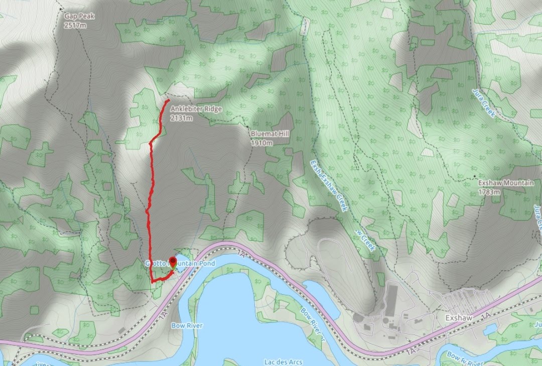
Anklebiter Ridge – Hwy 1A, Grotto Pond, Exshaw, AB
· Round Trip: 5.4km;
Elevation: 2142m; Elevation Gain: 842m; Time: RT – 5:20hrs (10:45-16:05),
ascent – 2:40hrs, descent – 2:00hrs; E-M scramble.
· Books:
References:
Drive
From Calgary, drive
west on Hwy 1 for about 63km and take the exit for #114/Exshaw. Head north then
west on Hwy 1X for about 4 km, turn left driving southwest on Hwy 1A for 10.8
km, then turn right into Grotto Pond parking lot. Driving time would be around 1:00
hour.
Hike
With an unstable weather forecast, we were not willing to
drive a long distance only getting snow and cloud. Therefore, we quickly agreed
to check out a front country scramble object - Anklebiter Ridge, a small bump
to the southeast of Gap Peak, and northwest of Exshaw Mtn, because it is much
easier to accept a no-view or even no-summit day if the drive is short.
When we arrived at Grotto Pond
parking, the snow pellets were swirling around in the wind and finally melted on the ground. We didn’t know what to do at first, but were inspired later by
other brave hikers who had no hesitation in putting their hiking boots. We then
geared up and started our hike fearlessly from Grotto Creek trailhead.
Just 3 minutes or 100 meters or so from
the trailhead, we left the main trail and followed an old track on the right to
the base of Anklebiter Ridge. From there, we turned right/north and walked up on
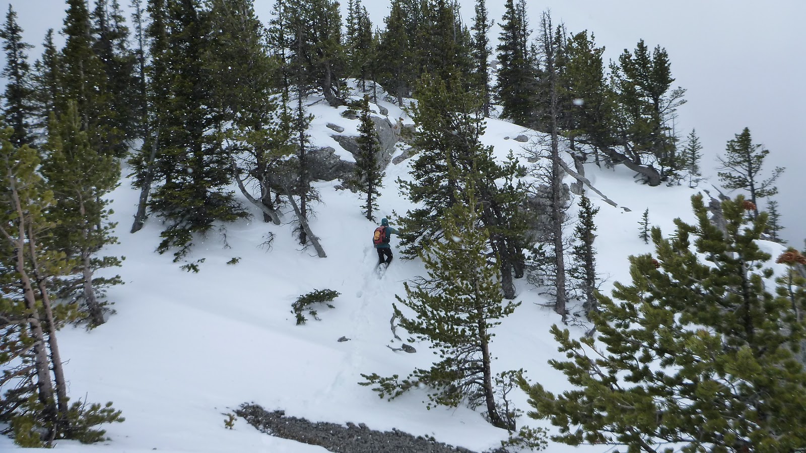
an obvious trail. The trail was easy and dry at first, but later became rugged
and snow-covered. There are various ways up, yet we chose to stay on the ridge
crest whenever we could for dirtying our hands to scramble up those rocks and
slabs. We didn’t encounter too much snow or difficulties before the false
summit, but did paid extra attention to some steep slopes with melting snow. After
the false summit, the snow was knee-deep. Even though we were following an old
packed track, we still sank in very often as the track wasn’t supportive
anymore due to the recent warming trend. After postholing for a short time, we
climbed up the last bit rocky section to reach the top of Anklebiter Ridge under
an icy blast.
The cold wind forced us went down a
bit to the east side for a shelter to finish our lunch. While having lunch, we
studied the alternative route down that would make a loop, but with the concern
of the fact that we might need to break our own trail, we finally decided to go
back the way we came. So, before retracing our steps to the car, we went back
to the top to take some photos while shivering in the cold wind.
Although the weather wasn’t in our
favour, we still liked this outing and were having fun of scrambling up and
down Anklebiter Ridge.
Trailhead for multiple trails

Leaving Grotto Canyon Trail to Steve Canyon Trail after 100 meters or so from the trailhead

An obvious trail from the base of Anklebiter Ridge

Hiking north on easy trail

Looking back for some views

Pigeon Mtn also in the mist

The ridge becomes rugged

First hands on

An unnecessary rope hanging on the tree

The easy part of the ridge

Hiking through trees

More rugged terrain

More hands on stuff

Looking down

Going around a rock

Staying on the ridge crest

Encountering shallow snow just before the false summit

False summit ahead

Bypassing deadfalls

Looking up the true summit from the false summit

Panorama from the false summit

The snow getting deeper and deeper after the false summit

Climbing up the last bit after some postholes

Looking southeast from the summit of Anklebiter Ridge under an icy blast

Looking south-southeast down to Bow River with Mt McGillivray(C) and Pigeon Mtn(R) above

Looking south-southwest towards the false summit with Gap Lake to its right

Grotto Mtn to the west

Gap Peak dominates the views to the northwest

To the north-northwest, Mt Fable is the most prominent peak in the area

Exshaw Ridge(F) and Morrowmount(R,B) to the northeast

Morrowmount(L) and Old Fort Peak(CR) beyond Exshaw Ridge to the northeast

Old Fort Peak(L) and Goat Mtn(CR) beyond Exshaw Ridge to the northeast

Goat Mtn(L), and Loder Peak(R) beyond Exshaw Ridge to the northeast

A closeup of Morrowmount

Descending the same ridge

The snowy treed ridge between two high points


Almost back to the false summit
A down climb

Looking down to Grotto Pond and the parking

The sky clearing to reveal Heart Mtn(CL) and McGillivray Ridge(R)

Heart Mtn with Twin Towers in the background right

Beautiful McGillivray Ridge

Pigeon Mtn to the south

Back on the Grotto Canyon Trail

Back to the trailhead

The end.
No comments:
Post a Comment