TRIP 271
Sunday,
01/14/2018, Strawberry Hills – Hwy940, Highwood Area, Kananaskis, AB
· Round Trip: 13.7km;
Elevation: 1985m; Elevation Gain: 483m; Time: RT – 6:40hrs (9:30-16:10), ascent
– 2:55hrs, descent – 2:15hrs; An easy to moderate snowshoeing trip with an
unexpected nice view and minimal avalanche risk
· Book: ‘Gillean
Daffern’s Kananaskis Country Trail Guide—Volume 5’ by Gillean Daffern
References:
Drive
From Calgary, drive south on Hwy 2/Deerfoot
Trail, take the exit for Okotoks driving south on Hwy2A for 10.9km, turn
right/west onto Hwy 7 towards Black Diamond. From Black Diamond, drive south on
Hwy 22 to Longview and then turn right/west onto Hwy 541 for 43.1km to Highwood
Junction, turn left onto Hwy 940 for 600m or so, park on either side of the
road. Driving time would be around 1:30 hours.
Hike
Even though the name
sounds delicious, I still put this trip on the bottom of my list for its low
elevation. However this week, with no other object suitable for the uncertain
weather and high avalanche risk forecast, we quickly locked up Strawberry Hills
as our target.
Wearing our snowshoes, we had a pleasant hike on the well packed Fitzsimmons
Creek Trail that led us westward through the trees, ponds and meadows. The view
opened up by the time we reached the ponds so we stopped frequently for photos,
thus slowed us down a bit. After 6 kilometres on the trail, we arrived at the
base of the ridge we planned to ascend. Here, we turned right and started bushwhacking
up northward along the ridge. Following the ridge, we reached our summit – the south
peak of Strawberry Hills - about one hour later at a leisurely pace.
The summit view was limited to the west, but unexpectedly great
especially under a blue sky. After cozily sitting on the windless summit in the
sun for 40 minutes, we started our descent. Since the view to the east is blocked
by trees, we decided to go down via the eastern ridge for some more views and making
a loop for the trip.
We walked down to the col between the south and east peaks through the
trees and then hiked up onto the east peak. There was a small cairn on the top,
and the view was more open than the south peak. Unfortunately, the clouds had
already rolled in and covered almost the whole sky. 10 minutes later, we
continued hiking down the ridge eastward to a col and then skirted a knob ahead
on its right/west heading southeast back to the Fitzsimmons Creek Trail.
My track
From the roadside parking, looking towards Highwood Junction with Junction Hill in the background

Walking on the well packed Fitzsimmons Creek Trail

The hike on Fitzsimmons Creek Trail was quite pleasant

The Fitzsimmons Creek Trail led us pass through the ponds

walking through the meadow with our object ahead

Turn left here. The snowshoe track ahead goes back down to hwy40

Trying to regain the trail after turning left

On the trail again

Mounts Armstrong(L of C) and Maclaren(C) appearing to the west

It's so nice to walk under a bluebird sky

No idea what this is

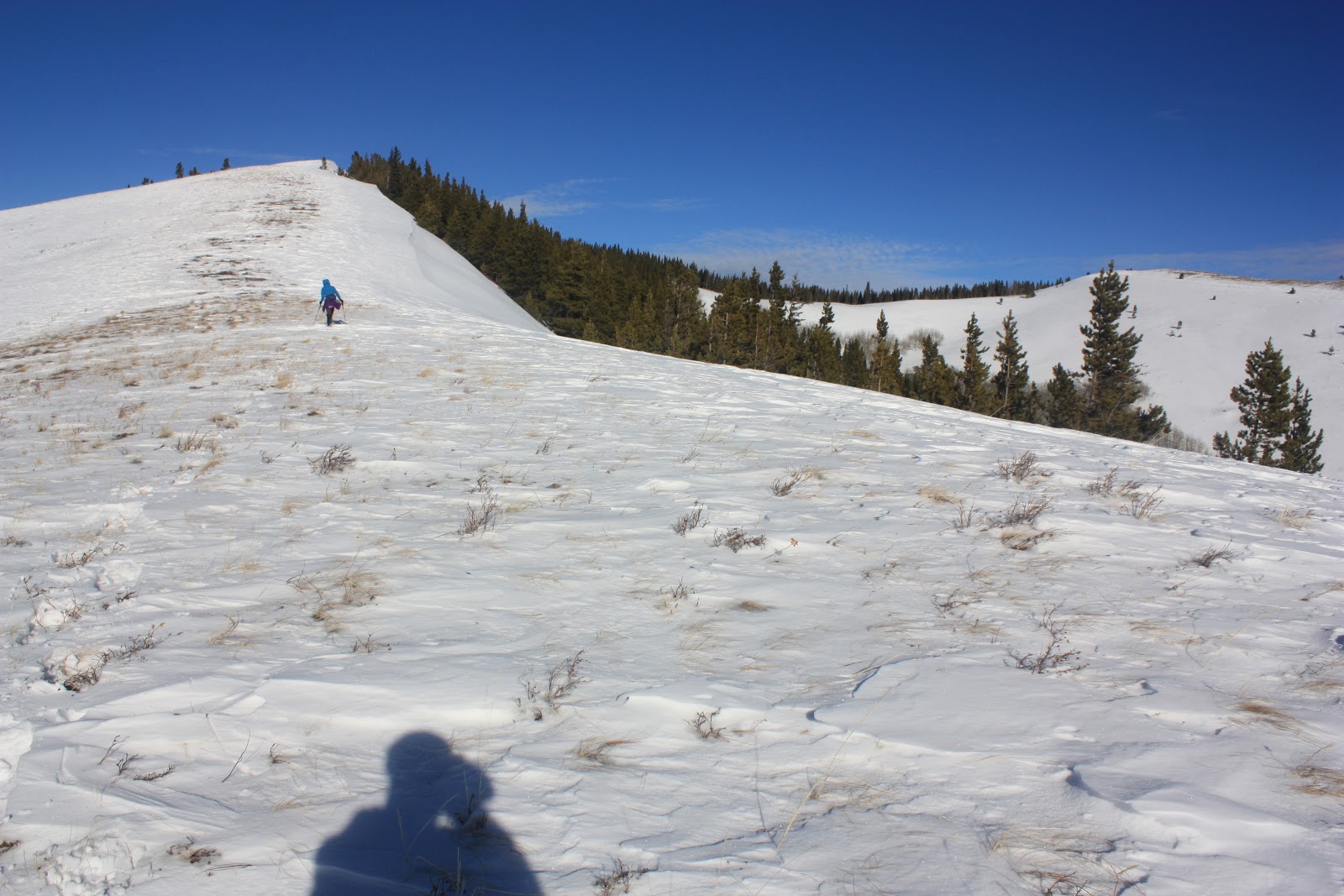
After 6 kilometres on the trail, we arrived at the base of the ridge we planned to ascend. Here, we turned right and started bushwhacking up northward along the ridge.


Breaking out of trees

Looking back to Coyote Hills through the branches

A much clear look of Coyote Hills

Nice ridge walk in the sun

The horizontal ridge in the skyline would be our descent route
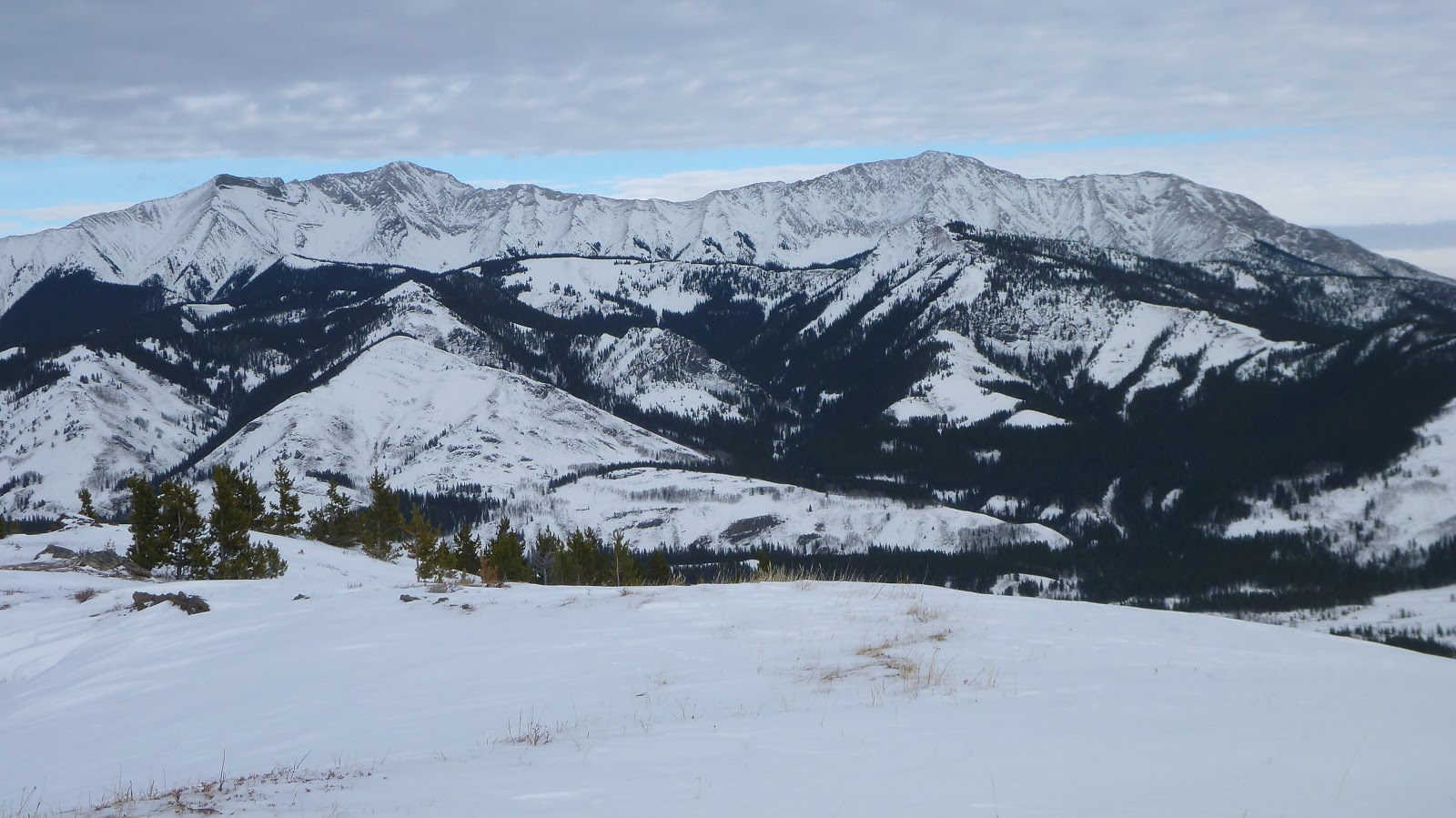
Mounts Armstrong(L of C) and Maclaren(R of C) to the SW

Behind Etherington-Baril Ridge(C) is Plateau Mtn

Leaning trees reveal the direction of the wind

Looking west beyond the highest peak of Strawberry Hills towards Mounts (l-r) Maclaren, Strachan, Muir, and McPhail from the summit of Strawberry Hills

View west-northwest towards mounts (l-r) Strachan, Muir, McPhail(CL) and Bishop(CR)

A closer look of Mounts Strachan, Muir, and McPhail

McPhail on the left and Bishop at right of centre

Mist Mtn beyond the North Peak of Strawberry Hills

The Hill of the Flowers in the foreground

Zooming in on Mist Mtn

The view to the east is blocked by trees

Interesting clouds and the summit

Baril Peak(CL) and Mt Armstrong(C) to the southwest

Mounts Armstrong(L) and Maclaren(R)

Leaving

One has to bushwhack a bit to the col between the south and east peaks

hiking up to the east peak

A Pano on the way to the east peak

Unfortunately, the clouds had already rolled in and covered almost the whole sky by the time we reached the east peak

View east from east peak

Looking SE to Coyote Hills(C) with Mt Burke and Plateau Mtn in the background

View south with Raspberry Ridge on left and Baril Peak at right

Looking southwest over our ascent ridge towards Mounts Armstrong(L) and Maclaren(R)

View northwest with the north peak of Strawberry Hills in the foreground right

There was a small cairn on the top, and the view was more open than the south peak

View north along Hwy 40

Mt Head(L) and Holy Cross Mtn(R) in the background to the northeast
Continuing down along the east ridge

Easy descent in boot-deep snow

Looking back at our footprints

The clearing sky to the northeast

To the west, (l-r) Baril Peak, Mt Armstrong, and Mt Maclaren were still under cloudy sky

Running down this snow slope, and then going into the trees ahead

Another look at Coyote Hills

Aspen under a beautiful sky

Easy bushwhacking

Back to the trail

The meadow seems in the shade all the time

Cat Creek Hills

Leaving the last opening

The end.
No comments:
Post a Comment