TRIP 247
Saturday,
7/29/2017, Mt Burstall – Hwy 742/Smith-Dorrien, PLPP, Kananaskis, AB
· Round Trip 10km;
Elevation: 2750m; Elevation Gain: 840m; Time: RT – 7:25hrs (9:40-17:05), ascent
– 3:30hrs, descent – 2:45hrs; Difficult scramble with exposure
· Books:
‘Scrambles in the Canadian Rockies’ by Alan Kane
References:
· Located in the Smith-Dorrien Creek
Valley, south of Burstall Lakes, and west of French Creek. Spray Range,
Kananaskis Park, Alberta.
· Latitude 50; 46; 20 Longitude 115; 19;
30, Topo map 82J/14. Panorama viewpoint: Old Elpoca Bridge. Can be seen from
Highway 742.
· Named in 1918. Burstall, Lt. General
Sir E.H. (Lt. General Burstall was the Commander of Canadian troops during WW
I.) Official name.
· First ascended in 1972 by M. Brown, I.
Carruthers, C. Cobb, B.E. Seyforth, guided by Bernie Schiesser. (from peakfinder.com)
Drive
From
Calgary, drive west
on Hwy 1
for about 60km and take exit 118, then head south on Hwy 40 for about 50km to
the Kananaskis Lakes Trail turnoff. Turn right and drive
2.2 km to the Smith Dorrien Trail/Hwy742 - Kananaskis Lakes Trail junction.
Turn right onto Hwy742 for another 20.1 km and park at Burstall Pass parking
lot (50°47'22.7"N
115°18'10.4"W or 50.789625, -115.302878) on the left. Driving time would
be around 1:40 hours.
On foot
Mt Burstall is a difficult, but awesome scramble with fairly short, easy and straightforward approach. Despite the fact that most parties finished it within 6 hours, and some hardcore even in 3 to 4 hours, we had a round trip time of over 7 hours. This, again, approves that we (actually Gua can be much faster if he doesn’t need to wait for me), apparently, move significantly slower than others do over difficult terrain.
And for this trip, since it is short, thus no rush, we then took our time to watch another two parties struggle with the back-sliding scree ramp on climber’s right towards the col. On our ascent, we looked back from the col and saw two hikers coming up via the scree ramp, but never met them on the top or elsewhere. In addition, we witnessed another party of two men trudging up the same scree ramp when we descended to the col, and later saw them stop ascending and back down from the col using Kane’s route instead. Both parties walked very slow and stopped frequently while walking on the scree ramp and couldn’t make it to the summit. I don’t know the reason they gave up, but can guess that the scree ramp they took is far far away from fun.
From the parking lot, after following Burstall
Pass Trail about 2.5 km, 35 minutes or so, 8 minutes past the big boulder
mentioned by Kane and many trail reports, we arrived at the turn-off. The cairn
on the roadside was broken, but there was another one at the tree entrance. We
turn left here and used the overgrown trail going through the trees around 15
minutes, and then went up to the bowl under the col in a short time. At that time,
the scree ramp further up climber’s right was so inviting that Gua couldn’t
help walking towards it, but was always corrected by me. I could tell why he
wanted to go up it. From our position, the scree ramp looked much less steep
and shorter than other ascent options. However, I knew, from many trail
reports, most of the parties went up the col using Kane’s route, and the best
bet would be the leftmost small rock rib running between the two black scree
slopes. Sure enough, this rib made our life much easier. While we were standing
on the col admiring the views behind, we saw two figures, the first party of
two seen by us in this mountain, making their way up via the inviting scree
ramp that almost brought Gua to its lure.
From the col, we turned right/SW to start
the ascent to the summit ridge by walking along a well trodden trail and then
slogging up through the steep and loose slope. The distance to the summit ridge
is short, but the tedious rubble slog was time consuming and giving me a hard
time. In fact, it was the most unpleasant part of the day. Once on the ridge, I
was glad that we could stand straight again. We mostly stayed on the ridge
crest, yet, you can use a scree path to the left to bypass. Within no time, we
were looking down the ledge leading to the base of the crux. From the ridge we carefully
down climbed a bit to our right to reach a one-foot-wide ledge and slowly
walked to the crux, a long crack in a huge slab angling up right to regain the
ridge. Climbing up the crack wasn’t too bad actually, since there were many
solid hand and foot holds, and I was too busy to look back and feel the
exposure. However, after regaining the ridge crest, we still needed to deal
with exposed terrains including climbing up a 3-metre high vertical slab with
good holds, but exposed to a cliff on left, and balancing over the exposed
broken ridge. After all the fun stuff, the summit was just a minute away.
The spectacular scenery as well as the blue
bird sky was compromised by the haze from the wildfire in BC since all
mountains were enveloped in thin smog. But the air was so warm and calm that we
felt like a long stay.
After more than one hour summit break, we
retraced our steps down to the lower part of the summit ridge. From there, we took
a trail on skier’s right first, and then had to traverse (because of the cliff
in the front) to the left onto the correct ridge and followed it backed to the
col. That was the time that we clapped eyes on the guys of the second party
coming up from the scree ramp. While scree-running down from the col, we
suddenly heard numerous rockfall clattering down from the scree ramp that the
second party was ascending. We stopped and looked up, yet saw nothing but dust
cloud. The rockfall lasted at least 10 minutes which concerned us a bit because
those two guys could be right on or very close to the rockfall path. Therefore,
we were so relieved when we later saw them appear on the col and start to
descend using our descent route. We then continued our work back to the parking
lot.
My track

Hiking along the Burstall Pass Trail with Mt Burstall ahead

Passing the big boulder mentioned by Kane and many trail reports

Arrived at the turn-off after following Burstall Pass Trail about 2.5 km, 35 minutes or so, 8 minutes past the big boulder

The overgrown trail led us through the trees in 15 minutes

Walking up towards the bowl under the col

The left-rising scree ramp was so inviting that Gua couldn’t help walking towards it, but was always corrected by me

Working the way towards the col

Our best bet

Sure enough, this rib made our life much easier

Looking back to (l-r) Mt Birdwood, Pig's Tail, Commonwealth Peak, and Commonwealth Ridge

Someone making his way up via the scree ramp looked uneasy

Looking NE towards Mt Chester(CL) from the col

The steep and loose slope leading to the summit ridge

Looking SE to (l-r) Cegnfs, Mt Murray, Mt Smith Dorrien (B), Prairie Lookout, Mt French (B), Haig Glacier, and Mt Robertson

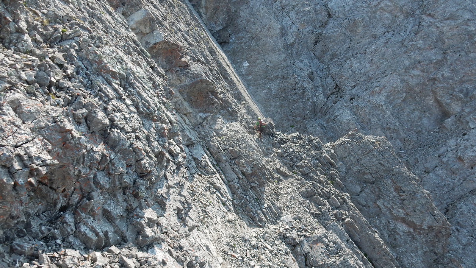
The scree ramp looked so innocent but was sold out by two hikers in the red circle

We tried to avoid the loose stuff by climbing the outcrops and slabs

The slope is foreshortened from this angle

Looking back towards the col

A beautiful pano behind

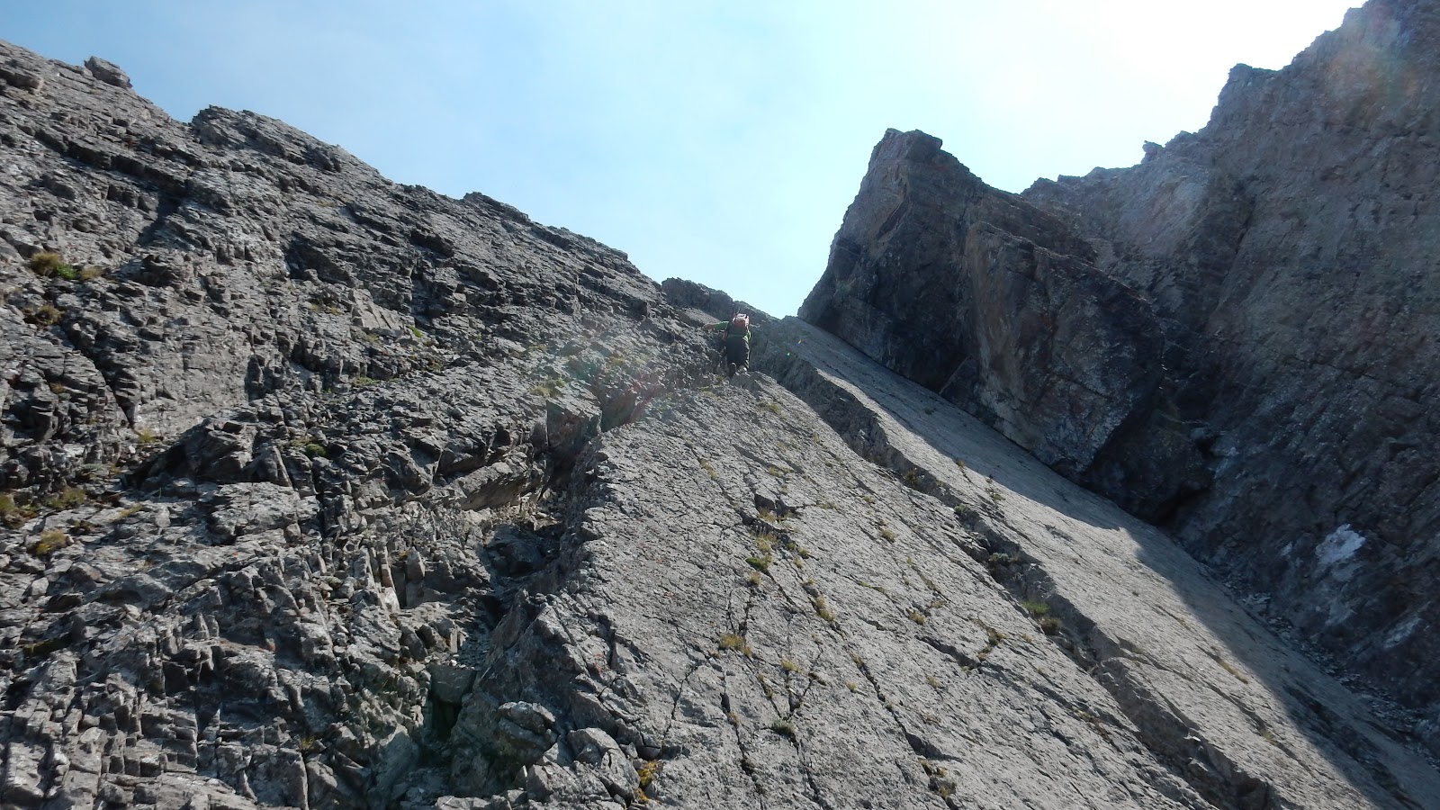
The tedious rubble slog was time consuming, and the slope is much steeper than it looks

Almost on the summit ridge

The narrow ridge and a scree path to its left. Gua was standing on the top of the ledge that leads to the base of the crux

From the ridge, carefully down climbed a bit to the right to reach a one-foot-wide exposed ledge

The approximate scramble route through the crux of the day

Start climbing the crux crack
We used the crack on left side
Close-up

Zooming out

Last step to regain the ridge

Climbing up a 3-metre high vertical slab with good holds, but exposed to a cliff on left

My turn to beat this 3-metre high vertical slab that with solid holds

Quite exposed after the 3-metre high vertical slab

Negotiating the exposed ridge


Next

The moves between the above and below pictures involved balancing over a short but exposed broken ridge

Summit cairn with the broken ridge on right and Kananaskis Range in the Background

The hazy view of Mt James Walker(b), Mt Chesmill(f,cl), Mt Inflexible(c), Kent Ridge North(cr), Mt Kent(far r) to the east.

Looking SE to (l-r) Cegnfs, Mt Murray, Mt Smith Dorrien (B), Prairie Lookout, Mt French (B), Haig Glacier, and Mt Robertson

Views south: (l-r) Prairie Lookout, Mt French (B), Haig Glacier, Mt Robertson(CL), Robertson Glacier, Mt Sir Douglas, and Whistling Rock Peak.

Mt Sir Douglas(L) and Whistling Rock Peak(C) to the SW with Mt Soderholm in the distance at right

Looking SW over Whistling Rock to Mt Leman(L,F), Sharkfin/Talon Peak(CL,B), and Mt Soderholm(C,B)

Views West towards (l-r) Mt Leval(CL,F), White Man Mtn(CL,B), Mt Vavasour(C,B), Snow Peak(CR,F)

Views NW: (l-r) Mt Birdwood(highest), Pig's Tail, Mt Smuts(CL,B), Commonwealth Peak(CR,F), Tent Ridge(B), Commonwealth Ridge, and the summit cairn of Mt Burstall(foreground right)

The sheer drop on the west side of the ridge

Mt Birdwood with distant Eon Mtn poking out from behind its left shoulder

Pig's Tail(L), Mt Smuts(CR,M), and Mt Shark(R,B)

To the north, Old Goat Mtn(CL,B) and Mt Nestor(CL,F) rising above Spray Lakes

One of the Burstall Lakes below to the north

Views northeast towards (l-r) The Tower, Mt Galatea, Gusty Peak, The Fortress, and Mt Chester

A sneaky company who couldn't stop eating

A pano (S/L - N/R) from the top of Mt Burstall

A Pano (N/L - SE/R) from the summit of Mt Burstall

Looking SE over the long ridge of Mt Kent to Opal Range

It's time to leave

The most difficult steps of the day required extra caution

Down climbing the 3-metre slab

Looking up the most difficult steps

It's quite exposed

The 3-metre downclimb


Climbing down the crack


Back on the lower part of the summit ridge via the narrow ledge

From the lower part of the summit ridge, we took a trail on skier’s right first.

Then had to traverse (because of the cliff in the front) to the left onto the correct ridge and followed it backed to the col.

The guys of the second party coming up from the scree ramp


Scree-running down from the col

Heard numerous rockfall clattering down from the scree ramp that the second party was ascending. We stopped and looked up, yet saw nothing but dust cloud.

Hiking down the glassy slope

Looking back towards the col

Back on the Burstall Pass Trail

The end.
No comments:
Post a Comment