TRIP 275
Sunday, 3/11/2018,
Mt Quirk – Hwy549, Fisher Creek P.R.A., Kananaskis, AB
· Round Trip: 25.4km;
Elevation: 1892m; Elevation Gain: Net - 408m, Accumulated – 950m; Time: RT – 8:30hrs
(09:25-17:55), ascent – 4:10hrs, descent – 3:20hrs; Strenuous hike.
· Books: ‘Gillean Daffern’s
Kananaskis Country Trail Guide—Volume 4’ by Gillean Daffern
References:
Drive
From Calgary, drive
west on Hwy 1 for about 16km and take the exit for Hwy 22 heading south, turn
left and keep driving on Hwy 22 when reach the 4 way stop in Bragg Creek. On
the T junction, turn left driving east for a short distance and then turn right
onto Hwy 762 for about 22.2 km, turn
right onto Hwy 549 for another 16.2 km until reach the winter gate, turn left
into the Fisher Creek parking lot. Driving time would be around 1:00 hour.
Hike
With high avalanche risk forecast, we had to choose a small object
in the foothill again even though the weather was terrific. Last time we went
to Fisher Creek Provincial Recreation Area to hike Mt Barwell, and this time we
would hike a long way to bag Mt Quirk, a small bump to the northwest of
Barwell.
From the parking lot, we marched along
the gated road for around 1.4 km without snowshoes, and then turn right (north)
before another winter gate and walked for another 1.3 km. Here, we turned left
(west) leaving the bare road onto the snow-covered Fisher Trail that runs along
Fisher Creek. Since it had been packed by Off-Highway Vehicles, we didn’t need
to break trail but did stumble a little on the uneven tire ruts. In a point
when the trail makes a sharp turn towards north, Gua was aware that it was too
early to make such turn. After consulting the map, we backed track a bit and
walked through deep snow to the correct trail that brought us to the ascent
ridge heading north. When this OHV trail turns left heading west down to the
valley bottom, we broke our own trail towards north in the woods instead. We were
treated for great views in several open areas along the way up before hiking
down a bit through knee-deep snow in the woods and then hiked up again to reach
the open summit bump.
This was a very long and strenuous
hike without much reward since the mountains are a bit too far away from us,
but the sun was so warm and cozy that we didn’t regret at all at the moment.
However, the tedious and exhausted return
almost killed our feet and legs. We didn’t talk much on our way back but only focused
on how to walk easier and faster on the tire ruts that now under melted snow. Finally,
we survived the long way back with sore hip, legs and feet.

Marching along the gated road for around 1.4 km

Turn right (north) before another winter gate

Turn left (west) leaving the bare road onto the snow-covered Fisher Trail that runs along Fisher Creek

A beautiful bluebird day

Stumbling a little on the uneven tire ruts

Crossing over a fancy metal bridge

Walking through deep snow to the correct trail

The steepest ascent of the day looks flat in the picture below

The ascent ridge heading north

Here, the OHV trail would make a sharp left (west) turn and go down to the valley bottom, and the route to Mt Quirk would go through the treed bump ahead.

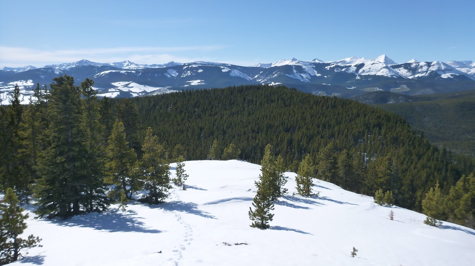
Great views looking NW along the way up

Hiking in the trees

Another viewpoint looking SW

Walking beside a long cliff

A camp?

Hiking down a bit through knee-deep snow in the woods

Hiking up again

Looking back to the treed ridge we came from with great views in the skyline

Last bit ascent to the open summit bump

Standing on the summit of Mt Quirk

Summit view towards south

View southwest
View west

Northwest

North

To the northwest, some tiny man-made structures can be seen on the top of Moose Mtn

Zooming-in on Prairie Mtn

Bluerock(CL) and Cougar (R) Mountains forming a backdrop to the SW

Looking southwest over Forgetmenot Ridge towards Banded(C,B) and Outlaw(R,B) Peaks

Mounts Cornwall(L) and Glasgow(R) rise beyond Forgetmenot Ridge to the southwest

l-r: Banded(L) and Outlaw(CL) Peaks and Mounts Cornwall(C/CR) and Glasgow peek from behind Forgetmenot Mtn and Ridge

Mt Glasgow in the background

On the right of the picture, Mt Remus(R,F) overlaps with Mt Romulus(CR,B) to the SW

To the west-northwest, peaks in the Fisher Range including Fisher Peak(L), Mt Fullerton(CL), Mt Howard(CR) rise beyond the seven km long ridge of Nihahi Ridge(summit at right)

From front to back: Nihahi Ridge, Mt Fullerton(CR), and Fisher Peak(CL) to the west

Compression Ridge(C) and Mt Bryant(?,R) to the northwest

The Massive Mt Bryant? with summit at left

Tiara(C,dark) and Belmore Brown(R) Peaks to the northwest

Prairie and Moose Mountains also to the northwest

The foothills to the north

A Panorama with the summit of Mt Quirk at right

Mt Rose(C, low) in the front of Cougar Mtn(CL,B)

Retracing our steps aiming the treed ridge ahead

Going down a bit before entering knee-deep snow slope

Back on the OHV trail

Back to the intersection missed on the way up

Struggling on the tire ruts that now under melted snow

So glad to see this welcome sign

The end.